Field of purple lupines along the Ring Road’s south section
Highlights
Description of places to visit along Iceland’s Ring Road. Suggested itinerary plus tips in planning a Ring Road adventure.
Description
You have come to the right place in planning your Iceland Ring Road adventure. Here, we describe some of the many places you can visit along Iceland’s famous Ring Road or Highway 1. These places are spread out throughout the Ring Road. What we listed here are the places we visited. There are certainly more but just not enough time.
Iceland’s Ring Road circumnavigates the entire country. It is approximately 1,322 kms (820 mi). Driving the Ring Road provides awe-inspiring scenery, however some of the iconic and beautiful places are away from the Ring Road. This greatly extends the time needed to complete the adventure.
We list these must visit places in a clockwise direction, beginning at the Westfjords, continuing to the north and east before heading back to Reykjavik on the south. We also describe two must not miss places in the highlands that require 4×4 vehicles.
Finally, we provide a suggested itinerary based on our experience.
Absent from this post is any information about places to see and do on the Golden Circle.
Places TO VISIT
Wesfjords
Kirkjufellfoss and Kirkjufell
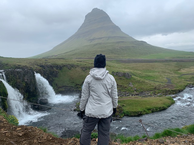

Chances are you will see many versions of the above picture if you search for images of Iceland. Kirkjufellsfoss (the waterfall) and Kirkjufell (the mountain) are such iconic representations of Iceland’s beauty.
This destination is about 3 hours north of Reykjavik and is a side trip from the Ring Road. But it is a side trip worth making as you can see from the photo.
Kirkjufellsfoss is on private property. But the landowner has a pay parking area to allow the public limited access to view the falls. The parking area is unmanned but there is a QR code that can be scanned to allow on-line payment with a credit card or Paypal. There are plenty of cameras at the parking area to ensure everybody complies.
To maintain the area’s beauty, visitors are required to stay within the designated walking path delineated by ropes. It is less than a five minute walk from the parking area to the viewing area.
There are several guest houses in the small town of Grundarfjordur as well as a couple of places to eat. There is also a grocery store (make sure you get there earlier than the 6 PM closing time).
Dynjandi
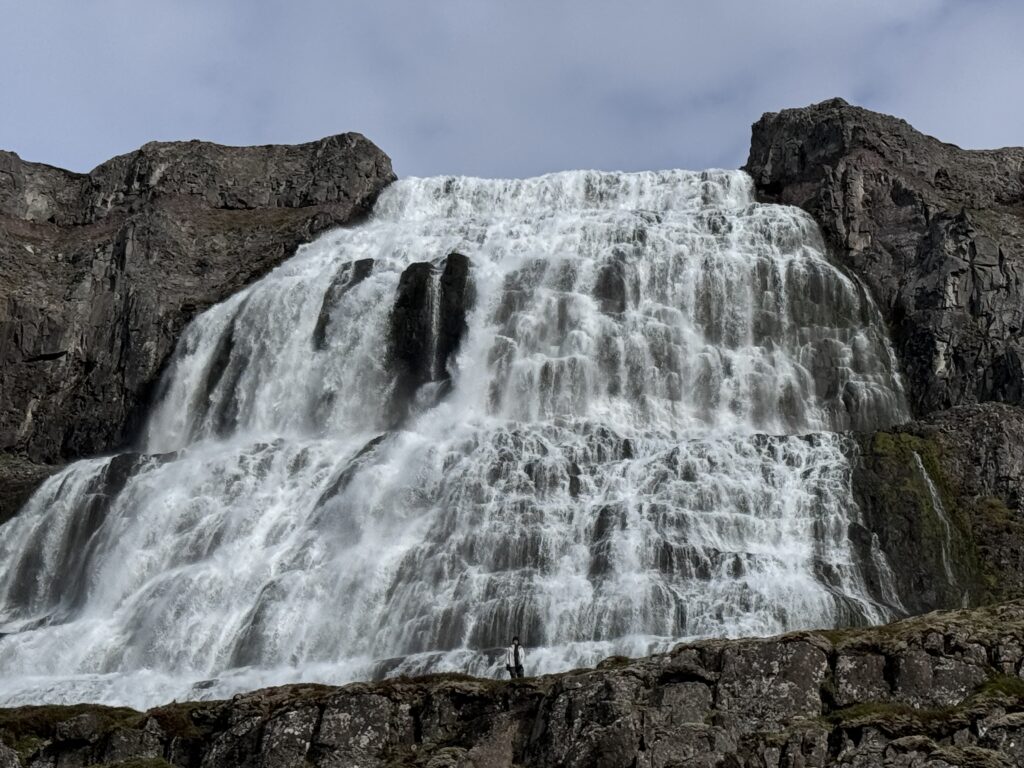

Dynjandi is a tall waterfall in the Westfjords. Dynjandi literally means thundering noise so the waterfall is appropriately named. The waterfall is 99 m (330 ft) high by 30 m (100 ft) and tumbles from the cliff edge over the cliff’s hard basalt. There are seven additional waterfalls downstream of Dynjandi before the water reaches the fjord.
There is a large pay parking lot. You need to have cell service in order to pay to park. A QR code is provided for ease of payment. There are also multiple single stall toilets at the parking lot plus a number of picnic tables.
It is approximately a 15 minute uphill walk to the base of Dynjandi. Along the way, visitors can stop and view the seven waterfalls up close. Benches are provided at some of the viewing platforms.
Dynjandi is about a 35 minute drive from Flokalundur with half being paved and the other half towards the falls being dirt. The road climbs in elevation and provides a few nice fjord views.
Latrabjarg
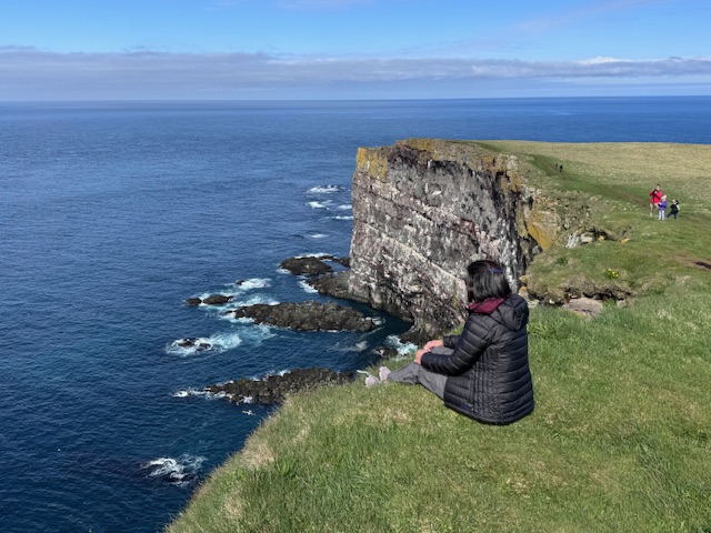

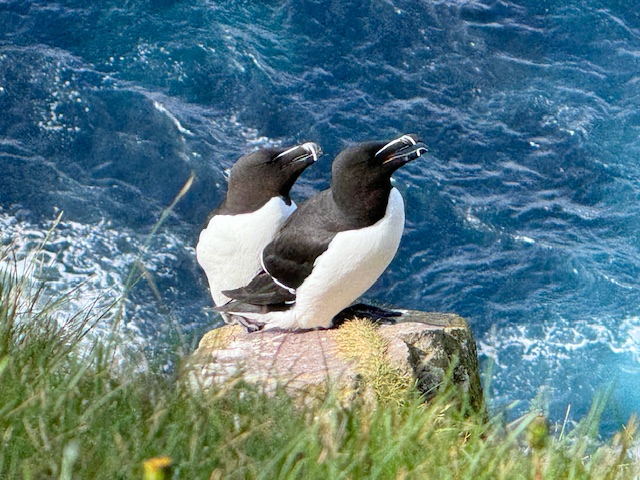
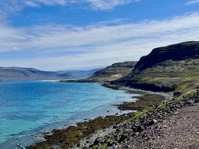
Latrabjarg demands an entire day, especially if you love sea birds. Puffins, razorbill, guillemot and fulmar nest on the vertical rock face of a long sea cliff. The scenery alone is worth the drive. We were surprised to see emerald colored water in this area. You would think you are in the Carribean or in the Pacific if it wasn’t for the cold air outside.


The road to Latrabjarg involves driving on unpaved road for about an hour.

North
Kalfshamrsvik and Hvitserkur
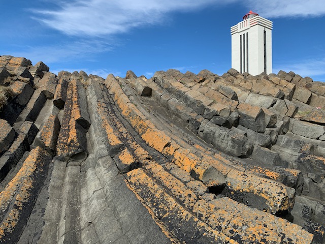


Kalfshmarsvik is an area where there are basalt columns right up to the sea. It is free to the public. The road to get there is not terribly bad either despite not being paved.
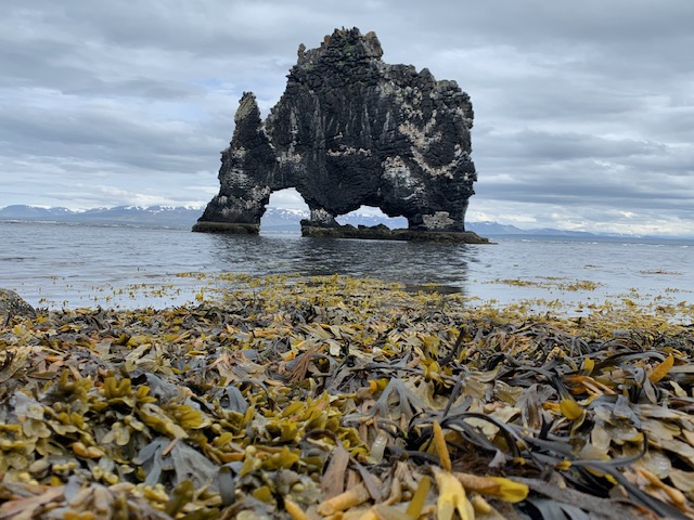
Hvitserkur is a three legged sea stack about a couple of hundred meters from shore. It poses magnificently with the snow covered mountains in the background. Sea birds can be seen nesting on its flat surfaces.
Reaching Hviserkur also involves driving on unpaved road as soon as you turn off from Highway 1 (Ring Road). Along the way, you will pass Borgarvirki, a hill dominated by fluted basalt rocks that has a caldera in the center.
You may be tempted to see the seals on the other side of the peninsula. Don’t even bother with it. The seals are at least 300 meters away such that all you can see is a blob lying on the rocks. To add to the disappointment, you have to pay 1,000 ISK to park and walk at least a mile to the viewing area.
Godafoss
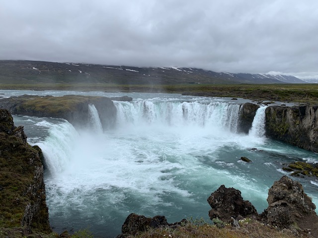

Godafoss is a large semi-circular shaped waterfall. There are two parking lots, one on each side (east and west) of the river. It is less than a five minute walk from the parking lots to the viewing areas.
The viewing area from the east parking lot offers the best view. You can also walk down to the river bank and view the falls from a low vantage point which is not as impressive compared to the viewing areas (just do not bother going down is what we are saying). There are no toilet facilities here but there is a cafe/store that charges for the use of their toilet. You can only pay by credit card to use the toilet.
More Puffins
Oxarfjordur Beach Point of View is on the Husavik Peninsula and just off the side of the road. Different species of sea birds nest on the cliff face. We made this out of the way drive because of the large number of puffins there.
Dettifoss and Selfoss


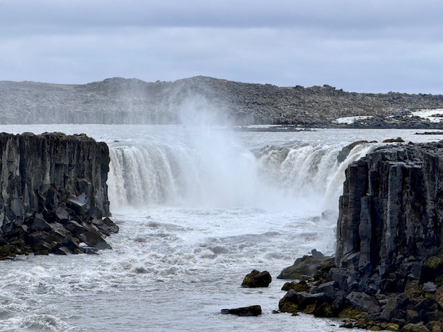

Dettifoss and Selfoss are two powerful waterfalls less than a kilometer apart. It is about a kilometer walk from the parking area to the two waterfalls. Visitors can get near Dettifoss such that you can get wet with its mist. Selfoss on the other hand can only be viewed from about 200 meters away as they closed the trail during the time of our visit.
Myvatn Nature Baths, Grjotagja and Hverir


Myvatn Nature Baths is the little brother of the Blue Lagoon near Reykjavik. It charges much less than Blue Lagoon too for the same experience. The water is soothingly warm. The facility has two main pools, a warm pool and a not so warm pool.
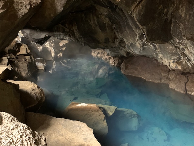

Grjotagja is a cave with thermal water. Unfortunately, bathing is forbidden. One of the scenes in Season 6 of Game of Thrones was filmed here.


Hverir is a thermal area with boiling mud pots, steam vents and a red mountain landscape that you would think is Mars. It is in private land so visitors have to pay to park to access the area. A marked foot path takes visitors alongside the different thermal features. The foot path can be muddy after a rain.
Viti Crater and Outdoor Shower


Viti Crater is an emerald color lake that shimmers under the sun. There is a trail around the lake that goes up to the top of the mountain behind the lake. Unfortunately, it was cold and windy during our visit plus the trail was muddy that we passed up hiking the trail. There is an outdoor shower that you will pass on the way to Viti Crater. The water is warm but could feel cold when the wind blows as it is exposed. It is also just off the road side.
East
Stuðlagil


Stuðlagil is a must see on the Ring Road. The basalt columns on each side of the river is just unique. It is a popular destination so do not expect solitude here unless you are there really early. There are two ways to see the river and rock formations – from the west and east banks. Googlemaps will take you to the west bank to the viewing platform. The east bank is much better as you can roam up and down the bank. To get to the east bank, follow the direction for Stuðlafoss. It is a 30 to 35 minute walk from the parking lot to Stuðlagil. Allow at least 2.5 hours.
Rjukandi Waterfall is a large waterfall off the roadside not far from the turnoff from the main road going to Stuðlagil.
Hengifoss
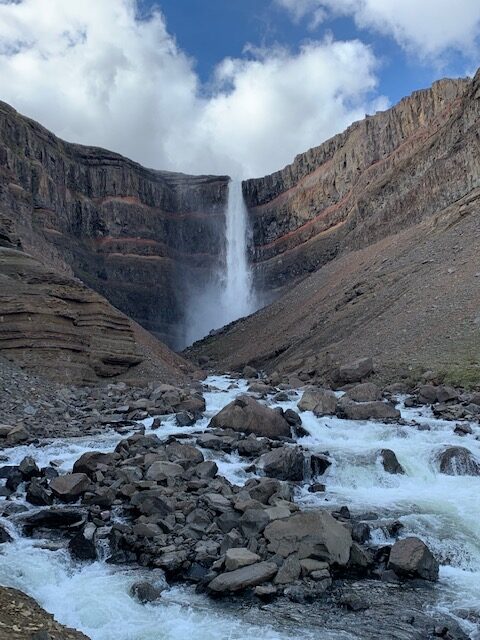

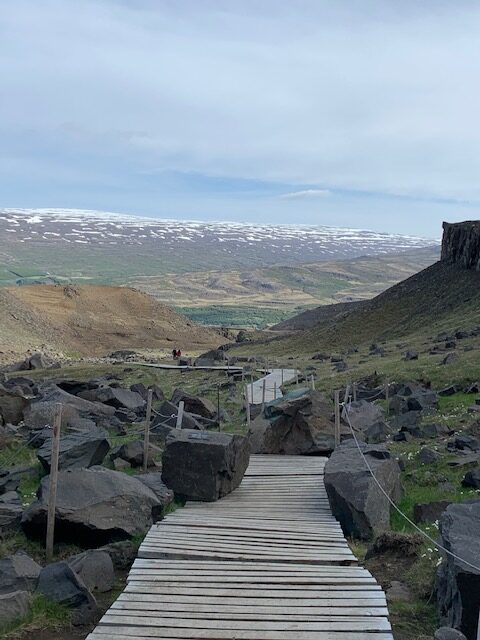

Hengifoss is the second highest waterfall in Iceland. It drops 128 m (420 ft) over the edge of the Fljótsdalshérað plateau.
It involves an hour of uphill walking to see the waterfall. There are two trals from the parking lot, one on each side of the river, that takes visitors to the watefall’s viewing area. The trail on the left is steeper but shorter while the one on the right is less steep but slighly longer. The steeper trail has more canyon scenic viewpoints.
The trails meet up later up in the mountain at a bridge over the river. Then the trail continues on to the viewing area. Allow at least two hours to visit the falls. One hour to go up, 40 minutes to get down and 20 minutes to take photos.
Seyðisfjörður


Seyðisfjörður or Seydisfjordur is a coastal community that is surrounded by mountains. We instantly regretted not having to have spend a couple of nights here. The place is just beautiful. There are also several waterfalls close to town that are waiting to be explored.
South
Scenic Places along Highway 1


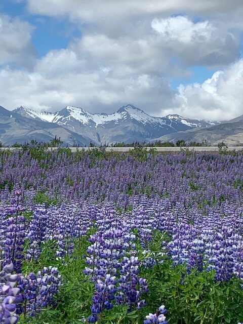

Highway 1 from the Fossadalur Campsite to the turn-off to Stokknes runs between the mountains and the ocean. There are many wonderful viepoints along the way. Fields of purple lupines are plentiful once Highway 1 veers more iinland.
Glacier Views
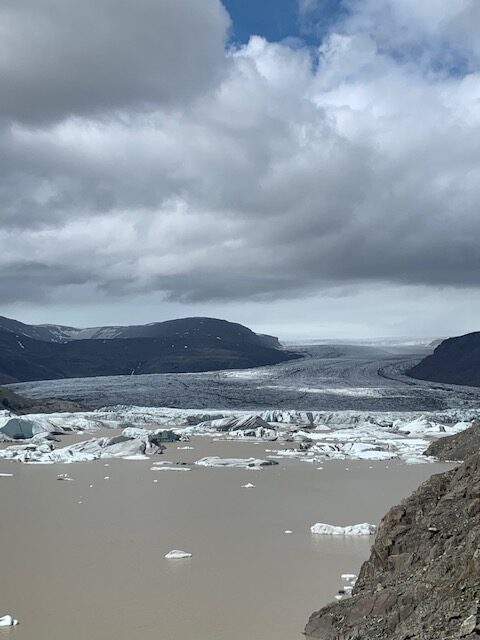


Hoffelsjokull, Jokulsarlon and Fjallsarlon all provide wonderful views of glaciers. Hoffelsjokul can be reached via four kilometer gravel road that requires 4×4 vehicles. You will find no crowds here. Jokulsarlon is the busiest as it readily accessible from Highway 1. Here you will see large chunks of icebergs. The famous Diamond Beach can be accessed here. Fjallsarlon is less busy than Jokulsarlon but can bring in crowds every once in a while. The glacier viewpoint is a short five minute uphill walk from the parking lot.
Mulagljufur Canyon


Mulagljufur is a verdant canyon that has a couple of waterfalls. The Svartifoss Trail begins at the parking lot and ends at a vantage point at the end of the canyon. It takes approximately 45 minute to an hour one way to complete the trail. The trail climbs in elevation and provides canyon, glacier and sea views.
Vatnajökull National Park
We should have stayed an extra night here. There are two wonderful hikes – Svartifoss and Sjónarnípa.


Svartifoss is unique because of the beautiful basalt column that frames the waterfall. The waterfall viewing platorm can be reached via 1.8 km (one way) trail on a substantial incline. Though the trail may be steep, it did not feel difficult. It normally takes 45 minutes to reach the waterfall from the trailhead which is at the campgroud.


Sjónarnípa is approximately a 6.4 km out and back hike to a spectacular viewpoint of the Skaftafellsjökull Glacier. This hike can be easily combined with the Svartifoss via 2.3 km S6 connector trail. This will make it a loop hike. It would be best to go to Svartifoss first then Sjónarnípa – clockwise direction. This way, most of the elevation gain is done. Then it is gradual descent back to the parking lot. It took us 3 hours and 20 minutes to complete the loop.
Fjaðrárgljúfur
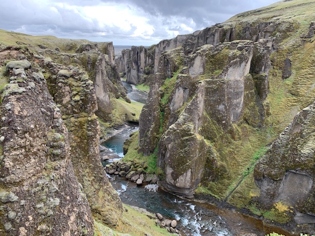

Fjaðrárgljúfur is a canyon that is about 100 m deep and a little over one kilometer long. What makes this canyon a popular destination is because of the various large rock formations along the canyon wall. A steadily ascending trail on the canyon’s east side leads visitors from the pay parking area to various viewpoints.
Vikurfjara


Vikurfjara is a black sand beach in the town of Vik. Access to this area is free unlike the Reynisfjara where visitors must pay to park. We went to Vikurfjara mainly to view the sea stacks.
Skógafoss is a large and powerful waterfall just off Highway 1. Unfortunately, we were short on time and decided to skip it as we have seen this waterfall back in 2019.
Seljalandsfoss is another iconic Iceland waterfall. Just like Skógafoss, Seljalandfoss is just off Highway 1. What is unique about this waterfall is that you can walk behind it without getting wet.
The Highlands
Gullfoss
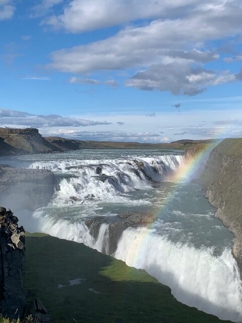

Gullfoss is considered part of the Golden Circle attractions but we included it here because it is along the way to Kerlingarfjöll. It is truly a magnificent waterfall especially on a bright sunny day. Gullfoss is only a couple of hours drive from Reykjavik.
Landmannalaugar and Kerlingarfjöll


Landmannalaugar and Kerlingarfjöll are two of the more popular destinations in the highlands. Going to these beautiful places require a 4×4 vehicle as you will be going on F-roads. Some F-roads are closed during the winter and into the spring when the snow on the road is not completely gone. Also, river crossings could be treacherous due to high water from snowmelt.
Our rental car agent said that F-roads were beginning to be opened up when we arrived in mid June. We went to Landmannalaugar and Kerlingarfjöl at the end of June and the roads were fine for the 2022 4×4 Dacia Duster that we rented. The only thing that got us worried was the stream crossing to get to Landmannalaugar but we made it through without issues.
Hveravellir Nature Reserve
About an hour and a half north from Kerlingarfjöl on F35 is the Hveravellir Nature Reserve. We did not make it to this destination because of the bad weather we encountered that forced us to spend an extra day in Kerlingarfjöl instead of going to Hveravellir Nature Reserve.
The attraction in the nature reserve is the geothermal pool and its hiking trails.
Suggested 14-Night Itinerary
Day 1 – Arrive in Keflavik (assumes morning arrival). Pick up rental car, shop at Costco and grocery store for provisions, Drive to Westfjords – see Kirkjufell. Stay at Grundarfjordur. There are many guesthouses in Grundarfjordur.
Day 2 – Drive to Flokalundur, see Dynjandi. Stay at Flokalundur Campground or in their hotel for two nights.
Day 3 – Day trip to Latrabjarg.
Day 4 – Long drive to head east and see Hvitserkur. Stay in Skagastrond Campsite
Day 4 – See Kalfshanarsvik and continue driving east to Akureyri. Stay a night (or two) in Akureyri.
Day 5 – See Godafoss, Oxarfjordur Beach Point of View, Dettifoss, Selfoss. Stay at Bjarg Campground. Take an evening dip at Myvatn Nature Baths.
Day 6 – Long day so start early. See Grjotagja, Hverir, Viti Crater, Stuðlagil, Hengifoss and Seydisfjordur. Stay at Seydisfjordur.
Day 7 – Explore the surrounding area in Seydisfjordur.
Day 8 – Scenic Places along Highway 1, Hofsjokull, Jokulsarlon, Fjallsarlon, Mulagljufur. Stay at Skaftafell Campground.
Day 9 – Hike Svartifoss and Sjónarnípa in Vatnajökull National Park. Stay another night at Skaftafell Campground to avoid a long and tiring day.
Day 10 – See Fjaðrárgljúfur, Vikurfjara, Skógafoss, Seljavallalaug, Seljalandsfoss. Eat at Vik before heading to Lindartun Guesthouse.
Day 11 – Landmannalaugar
Days 12 – Kerlingarfjöll
Days 13 and 14 – Reykjavik. Do the Golden Circle.
Day 15 – Fly out
Tips
Notable Places to Stay
Westfjords
Kirkjufell Guesthouse at Grundarfjordur is clean and comfortable accomodation with shared bathrooms and kitchen.
Flokalundur has a campsite, gas station, hotel and restaurant. The campsite at Flokalundur has flush toilets, hot showers, electric hot water kettles and some picnic tables. It also has a nice view of the bay and is in a quiet location despite being near the road (not a lot of traffic).
North
Hotel Halond in Akureyri is a find. Reasonably priced, clean, modern and spacious. We would have wanted to stay an extra day here to take a break from all the driving and camping.
Bjarg Campground is about a 10 minute drive from Myvatn Nature Baths which makes it a convenient location. The campground has buildings that house toilets and showers. There is also a hair dryer in the building. There are outdoor sinks for washing dishes. It does not have any cooking facilities. Cash payments only.
East
Seydisfjordur has a campsite and a few guesthouses and hotels. There are also restaurants.
Fossardalur Campsite is a highly rated campsite for good reasons. It has a large dining and kitchen hall. There are six induction cooktops each having two hot surfaces. There are some pots and pans but it is best to bring your own unless you want to wait for your turn when others are using it. The only drawback of this campsite is that there are only two showers and water pressure can sometimes be low especially when there are a lot of users. But its free Wifi cannot be beat.
South
Skaftafell Campground is a campground in Vatnajökull National Park. We decided to stay in this campground because the initial campground we picked, Tjaldsvæðið í Svínafelli, did not have trees and was more exposed to the wind.
Skaftafell Campground is a big campground with separate areas from tent, car and campervan camping. There are electric hook-ups too. Its shower facility is nice and roomy. There are five shower stalls for each gender. There is no cooking facility but at least it is tucked away near the based of the mountain and sheltered from the wind.
Lindartun Guest House is located about 6 miles south of Highway 1. It is a nice accomodation with rooms with private baths. We picked this guesthouse because we wanted a short drive to our next destination – Landmannalaugar.
See separate posts for Landmannalaugar and Kerlingarfjöll for accommodation descriptions in these areas
Rental Vehicle
An ordinary rental car is all you need to access the destinations mentioned here, except for the highlands area which requires a 4×4 vehicle. See post on rental vehicle options for the Ring Road.
Weather in June
Expect to be cold and windy and changing all the time with the occasional rain. It is even more unpredictable in the highlands.
What to Wear
Bring your winter wardrobe to stay comfortable outside (upper and lower baselayers, beanie, gloves, buff, etc). Layering is better so you can shed in case the sun comes out or put on more when it disappears.
Rain jacket and rain pants are a must if you plan to hike outdoors.
Summary
Iceland’s Ring Road, also known as Highway 1 circles the entire island. It offers travelers a comprehensive tour of Iceland’s diverse landscapes and attractions. As it loops around the country, the Ring Road passes through an array of natural wonders such as waterfalls, glaciers, volcanoes, black sand beaches, geothermal areas, and fjords, making it a popular route for tourists seeking to experience the country’s unique and stunning scenery.
Key highlights along the route include the Seljalandsfoss and Skógafoss waterfalls, the glacial lagoon Jökulsárlón, the volcanic landscapes of the East Fjords, and the geothermal area near Lake Mývatn. Additionally, the road offers access to numerous national parks, such as Vatnajökull National Park, which is home to Europe’s largest glacier. Accommodations range from campsites and guesthouses to hotels, allowing for flexible and comfortable travel experiences.
Driving the Ring Road provides an unparalleled opportunity to explore Iceland’s rugged beauty and natural beauty making it an essential adventure for those visiting the country.

