Summary
This blog describes our experience and how we end up using Google Maps and Maps.me for car navigation while driving in Austria, Italy and Spain in 2021.
Navigation Options
First time we drove in Europe was in 2019. Our leased car came with an in-dash global positioning system (GPS). It said so in the quote so we did not have to worry about it. The second time we drove in 2021, we were not sure if the rental car would come with a GPS or not. Our first rental car had an on-dash GPS so we lucked out. Our second car had an on-dash screen without GPS. I will continue this story later.
In preparation for our 2021 European trip, I searched the Internet on how I could have navigation in case our rental car did not have a GPS. Some said to pay Garmin so I can download the European base map to a micro SD card and insert it in my Garmin GPS so I can bring it on our trip. Dang, more stuff to carry, especially the GPS stand. My one carry-on bag only travel motto is going to be put to the test. Not a good option so I searched some more. I read a blog that said most rental cars have navigation but not guaranteed (which I found to be true).
Some blogs said Google Maps works in Europe. I have an old 32 GB iPhone 6 that has no service. In the states, I download offline Google Maps into it for navigation. Sometimes it would route and sometimes it would not. More often than not, it fails to route whenever I need it the most. What I noticed is that offline Google Maps works if I launch the app while I have Wifi. Offline Google Maps would continue to work as long as I don’t close the app, meaning, the app would not work if I closed it and then opened it again.
I could not rely on offline Google Maps for our second European trip. My wife’s cell phone has an international data plan and her Google Maps works although it’s slow as molasses because it has LTE connection in Europe. At least that is one option without having to buy a Garmin European base map.
Finally, I read an Internet blog about Maps.me which is a free app where I can download a country’s base map to my smartphone. So I downloaded Austria, Italy and Spain to my old iPhone 6 and played with it while we were in the states. It looked promising so we went to Austria with Google Maps on my wife’s phone and Maps.me on mine.
Using Google Maps and Maps.me
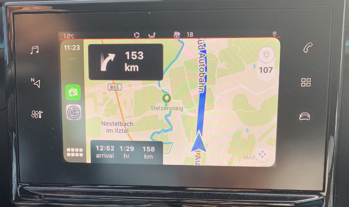
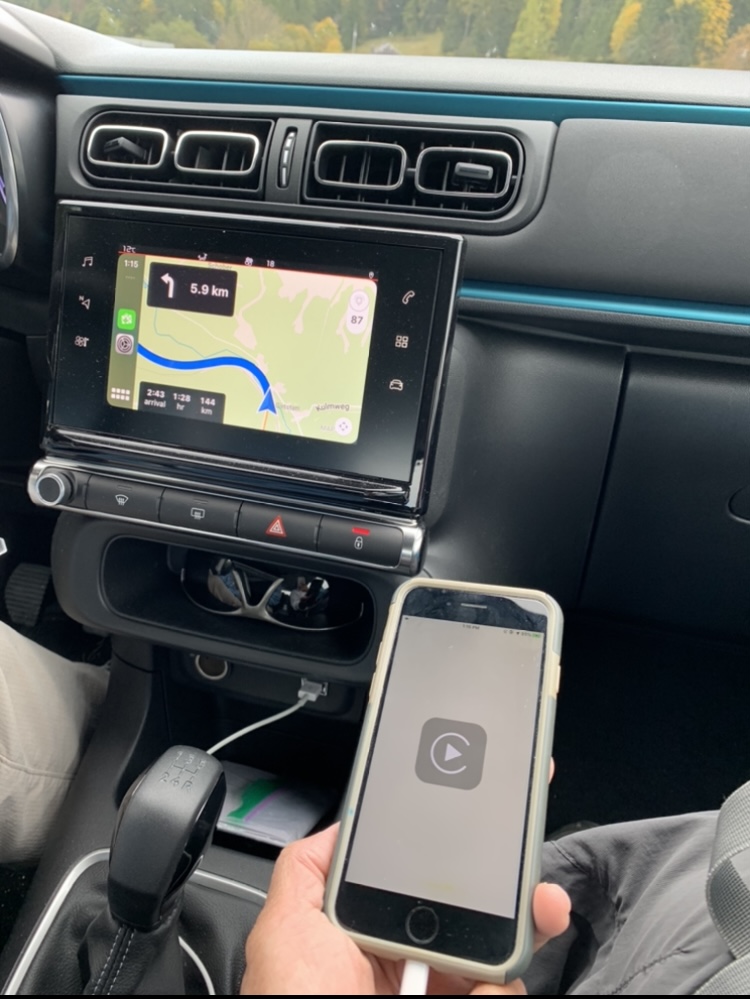
Back to the story about the second rental car in Austria that has no GPS but has an in-dash screen. We found that we can connect both of our smartphones to the in-dash screen using the USB cable. Viola, we have navigation (see photo).
Google Maps and Maps.me would sometimes route differently. We found that it is best to have both on while driving. Maps.me is a static GPS, meaning you get whatever is in the database at the time it was downloaded. Road closures and traffic delays would not show on Maps.me unlike Google Maps. Maps.me would appear to be frozen when going through tunnels as it cannot update the location. However, it would update soon after exiting the tunnel. Maps.me would warn us, most of the time, if we are approaching a speed camera in which Google Maps does not.
We also found that once the smartphone is connected to the in-dash screen and actively navigating, we could no longer use the smart phone’s other apps (as shown in the photo above). We had to stop navigation if we needed to Google something. So, we primarily use Maps.me for our in-dash navigation while my wife uses her phone and Google Maps to co-navigate. If we need to find a grocery store or gas station along the way, she could use her phone to look for one.
Before we set out driving, we use both apps to route our destination. Then we compare the routes if they are the same. If the routes differ, our default is to follow Google Maps thinking that it is more up to date. This proved true before while we driving from Salzburg to Lofer in Austria. The route requires us to cross Germany where there are more than a couple of ways to get to Lofer. The car’s GPS picked the shortest route while Google Maps picked a slightly longer route. Naturally, we followed the car’s GPS and we ended up facing a road closure about halfway on our journey. So we had to double back and followed Google Maps instead.
Maps.me Quirks
Maps.me worked flawlessly in Austria. However, it had its quirks when we used it in Spain. Let me describe first what we saw on the in-dash screen (user interface) before I describe the quirk. As with any navigation screen, a GPS has a particular zoom level where it thinks it’s optimal, meaning it’s not too zoomed out or not too zoomed in. On a highway, Maps.me’s zoom level would show us approaching an exit and the overpass but the overpass is pretty much at the top of the screen so we could not see where we would go next if it instructed us to exit the highway.
So the quirk is Maps.me would instruct us to exit the highway then get back on it again once we passed the overpass. Even at rest areas. It would instruct us to take the rest area exit then go through the rest area and continue back on the highway. We estimate that this quirky behavior probably happened about 40 to 50 percent of the time whenever we approach a highway exit.
That is why we always compare our Maps.me and Google Maps route before we set off to our new destination so that we know if we really need to take the highway exit or not when Maps.me tells us to do so.
Initially, we thought that this quirk may be due to an incorrect setting. But we decided it’s probably the database itself was not coded properly or not updated as it worked fine in Austria. Anyway, we never figured out why this quirk only happened in Spain.
Other Uses of Maps.me
Most of the blogs about Maps.me describe it as best for exploring an area on foot. We were able to test this whenever we were walking around town. Maps.me’s screen interface is better than Google Maps because of its perspective view.
I define perspective view as the view I see when I am actually standing and looking at the street in front of me. It makes foot navigation so much easier to follow compared to Google Maps whose default is North is up whenever we use it to navigate by foot (we never figured out a way to disable the North is up setting whenever we route by foot).
Final Thoughts
Car navigation is a must when exploring a foreign land. Car rentals may or may not come with a built in GPS. The chances of getting a car with GPS is primarily dependent on what is available at the lot at the time the rental car is picked up unless specified in the car rental.
Both Google Maps and Maps.me are good alternatives for car navigation. Google Maps requires a data plan to function. This allows the app to provide accurate routing information as it takes into account current road conditions (assuming it is up to date). It would be perfect if Google Maps was able to warn us if we were approaching a speed camera. But it does not unlike Maps.me..
Maps.me is 100 percent an offline navigation system, meaning it does not need data to function. However, its database resides on our smartphone which takes up space. The database is also static, meaning it is up to date at the time it was downloaded. Even if it was downloaded recently, it may not be up to date as its update is at the mercy of its users. Still, its ability to warn us of speed cameras is a big plus.
We found that having both Google Maps and Maps.me was the best way for us to navigate through Austria, Italy and Spain.
Related Blogs
Driving in Austria. Driving in Italy. Driving in Spain. Driving vs Public Transportation, Lease Vs. Rent.