Last Updated on July 25, 2024

Koca pri Triglavski jezerih translates to “cabin near Triglav Lakes”. We found this day hike from a hiking website that is our go to site for wonderful hiking destinations. It was labeled as the Seven Lakes Valley Hike. At first, we thought that we would see seven alpine lakes along this hike. On researching AllTrails, most comments we read mentioned they did not see seven lakes on the trail. Google Maps shows only three lakes along the route.
We decided to do the hike anyway as we have not done a long hike in more than three months. The hike is labeled moderate on our go to hiking website and labeled hard on AllTrails. We tend to agree with AllTrails. We don’t know how you could call a hike that is 15.2 kilometers (9.3 miles) long with over 1,000 meters (3,300 feet) of elevation gain and loss moderate. Maybe because our legs are no longer young.
This day hike was a little disappointing. The reward to effort ratio was low, meaning the beautiful sceneries were few and far in between for the amount of energy expended. Perhaps this hike is for those who just want to tone their legs, get a workout or make it part of a multi day hike by staying at Koca pri Triglavskih Jezerih. Here, we describe the hike and share our photos to help you decide whether to pursue this endeavor or look somewhere else.
Time of Visit: August 2023
Trailhead
There are multiple ways to reach Koca pri Triglavskih jezerih. Because our base was at the village of Srednja Vas, we started our hike from the Stara Fuzina trailhead. The trailhead can be reached by driving to the village of Stara Fuzina and taking a right just after (west of) the bridge onto Stara Fuzina road going to Planina Blato. A couple of kilometers from the village, you will encounter barrier arms on the road. One for entry and one for exit. The ticket dispensing machine is before the entry gate and the payment machine is before the exit gate. Parking cost was recently raised from 15 to 20 Euros per day. The payment machine takes cash and credit cards.
There is roughly 10 or more kilometers of narrow, winding and uphill road to get to the trailhead. Parking is on the side of the narrow road.
The Trail
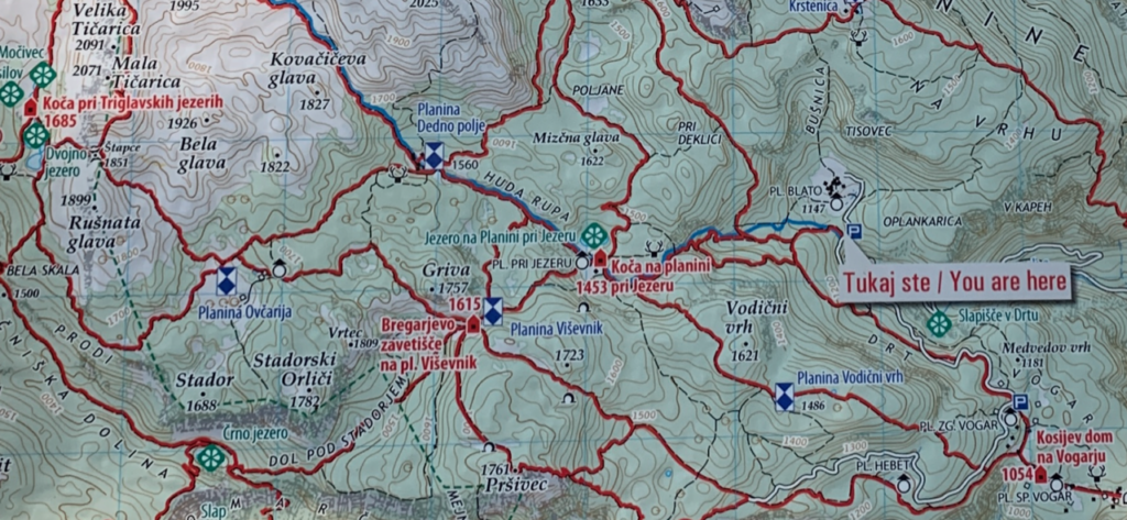
We will describe the trail in four sections. The first section is from the trailhead to the first lake which is where Koca na Planini pri jezeru (shown on Google Maps and in the map above) is located. The second section is from Koca na Planini pri Jezeru to Planina Ovcarija (text in blue in the map above) via Bregarjevo zavetisce na pl. Visevnik.
The third section is the lower leg of the circular route between Planina Ovcarija and Koca pri Triglavskih jezerih. This lower leg of the circular route is what most hikers take because it has more elevation loss than gain en route to Koca pri Trilavskih jezerih. The last section is the upper leg of the circular route between Koca pri Triglavskih jezerih and Planina Ovcarija. This is the route we took on the return trip because we wanted to take the short but steep route instead of taking the same lower leg going the other way which has a long uphill climb.
Majority of the route has loose rocks. This makes descending on the trail hazardous if you do not pay attention to where you are stepping. We managed to complete the hike without any incident though it took us almost 10.5 hours, including a one hour lunch at Koca pri Triglavskih jezerih and occasional breaks. Granted we were slower than most people.
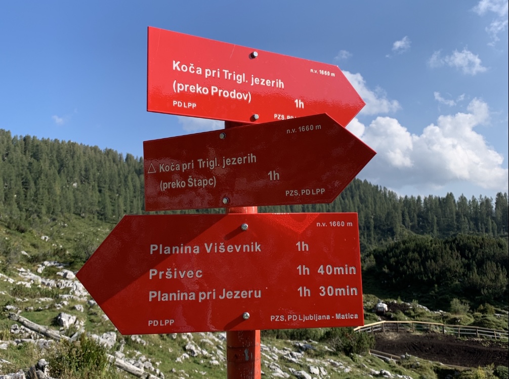
There are directional signs along the trail. The signs also indicate the expected time to reach the next junction or destination.
Section One, Trailhead to Koca na Planini pri jezeru
Expected time – 1 hour.
The trail immediately ascended from the trailhead and did not let up until we reached Koca na Planini pri jezeru. The trail mainly goes through a forest of deciduous trees. There are no views along this section until you reach the cabin (Koca).
If you are hiking this section early in the morning or late in the afternoon, expect to be spared from the sun. The trail is on the side of the mountain that blocks the sun. The trees also provide sun cover.
At about 10 minutes from Koca na Planini pri jezeru, conifer trees become more dominant and deciduous trees begin to thin out. The trail becomes more exposed by late morning and early afternoon as the conifer trees do not provide as much shade on the trail by virtue of their short branches.
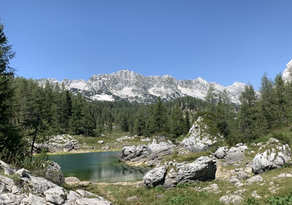
The cabin is in a clearing and some mountain peaks become visible from the trail. This is your first opportunity of taking photos after an hour of huffing and puffing. You can have snacks at the cabin and take pictures by the lake before continuing with the hike. If you are lucky, the cows may be there to greet you.

Section Two, Koca na Planini pri jezeru to Planina Ovcarija
Expected time – 1 hour 30 minutes.
The trail continues its uphill climb. Some stretches may look intimidating as you face the steep trail. The trail opens up again at the village of Bregarjevo zevetisce na planini Visevnik. This is your second opportunity to take photos.

There is a constantly flowing water fountain where you can fill up your water bottle. The water that came out of the fountain was refrigerator cold and refreshing. There are a few structures in the village. We saw some hikers that appeared to be spending the night at this village on our way back.
Continuing on, the trail eases off on the climb and becomes a series of ups and downs before reaching a shallow valley. From here onwards, the trail is more open such that you can take photos more frequently until you reach the Koca pri Triglavskih jezerih.
Descend down the valley to Planina Ovcarija to begin the third section of the hike.
Section Three, Planina Ovcarija to Koca pri Triglavski jezerih (preko Prodov)
Expected time – 1 hour 15 minutes (1 hour on the sign)
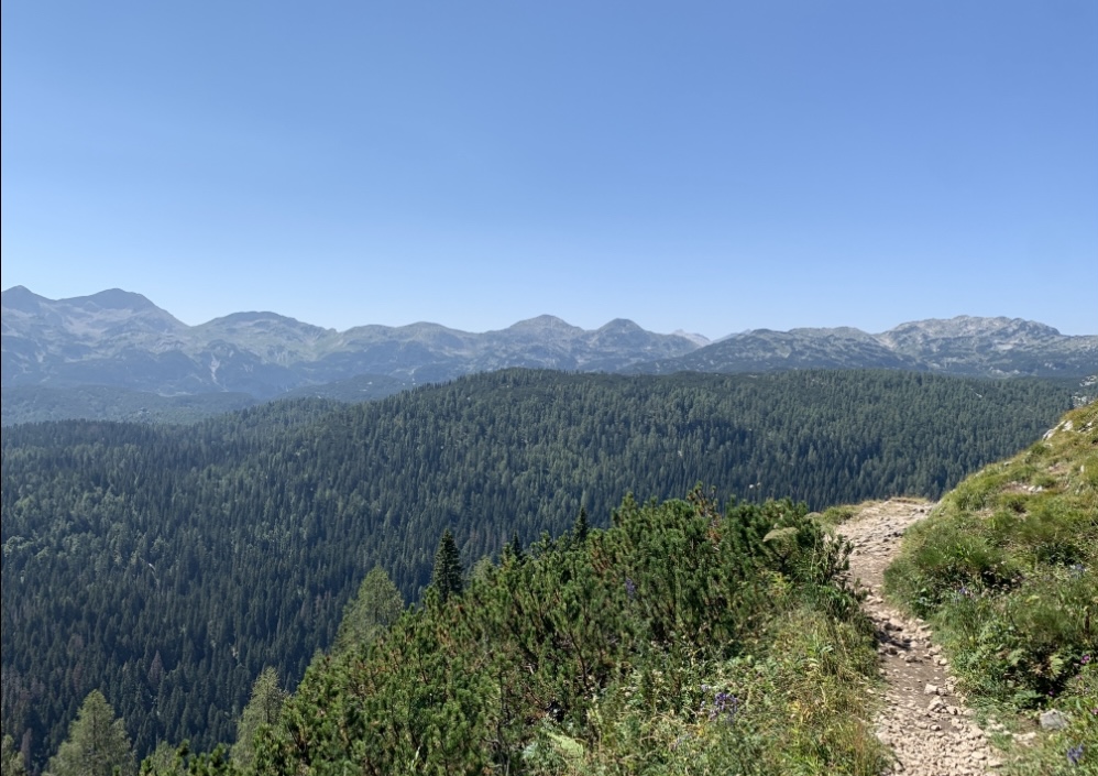
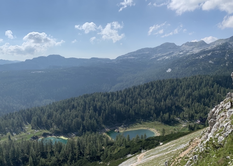
The third leg is “preko Prodov” or via Prodov. The trail from Planina Ovcarija goes on a slight incline through a low tree line before emerging on the side of a mountain slope where it would descend. Prior to the descent, the vast valley and the mountain range behind it lies in front of you. It reminded me of a section of the John Muir Trail in Sierra Nevada, California. It would be nice to pause here to soak in the scenery but more than likely you just want to reach Koca pri Triglavskih jezerih to have a meal break.
The trail descends down for a few hundred feet before ascending back up as it rounds the side of the mountain. It then levels off and the lake and cabin becomes visible about 15 minutes later.
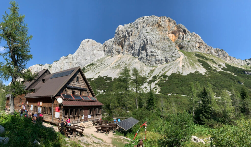
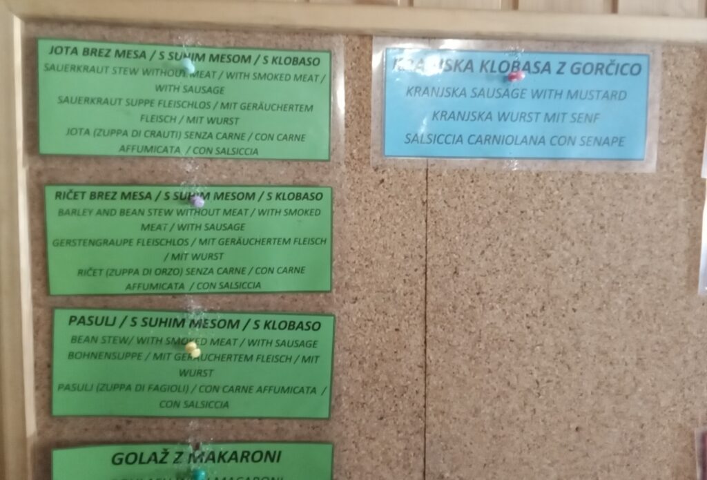
The cabin has a limited menu on the wall inside the eating area. It is an off the grid cabin so do not expect any ice here, only cold drinks. The bottled soda drinks are pricey at 4 Euros a bottle while the barley and/or bean stew with or without meat are more reasonable at 10 to 15 Euros. Do not forget to fill up your water bottle from the outside faucet with refreshingly cold water. It tastes better than the soda drinks.
Section Four, Koca pri Triglavski jezerih to Planina Ovcarija (preko Stapc)
Expected Time – 2 hours (1 hour on the sign)
Retrace the trail back until you reach the western junction of where section three meets section four. This junction is approximately between the two lakes. The trail goes briefly but steeply through the tree line before continuing up on the side of the mountain that looms over the cabin and the lakes. The trail is wide but on loose rocks. Do not forget to look back at the view behind you.
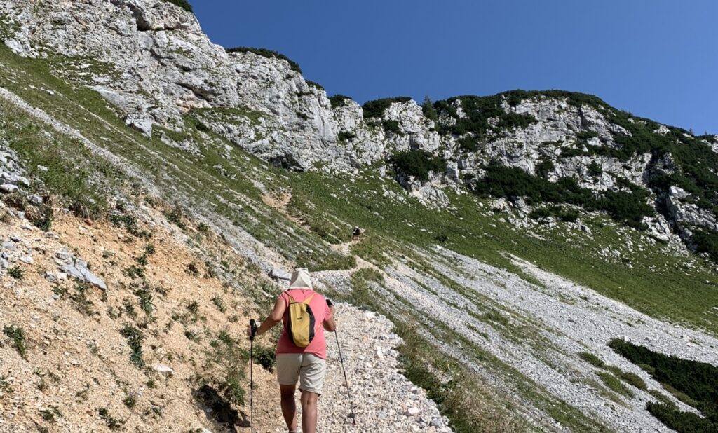
The iron steps and cables become visible as the trail nears the mountain summit. Here comes the final push to get over the mountain. Overall, a strong hiker should get over the mountain in less than 40 minutes. We took around an hour.
On the other side of the mountain the trail descends at a less steeper slope compared to the one we just conquered. Nonetheless, we were still careful as we were stepping on and over rocks that could make us slip or trip. If you hit this section late in the afternoon (4 pm or later), you will be glad that the mountain you just conquered shades most of the trail until Planina Ovcarija.
Summary
The Koca pri Triglaviskih jezerih hike is also known as the Seven Lakes Valley hike. The destination is the Koca (cabin) or hut by two small lakes. The Koca can be reached from multiple starting points. We started our hike from the Stara Fuzina trailhead which can be reached by driving the road leading to Planina Blato. There is a bus that drops off hikers about 600 meters before the trailhead. However, the bus has a limited schedule and is a long walk back to the village of Stara Fuzina if you miss the last bus of the day.
According to the trail signs, it takes a total of 3 hours and 45 minutes to reach Koca pri Triglaviskih jezerih without any breaks. For the first hour and half, the trail constantly ascends. The trail has shade trees for the first hour before becoming exposed as the trees transition from deciduous to conifers.
The trail opens up and the mountains become visible more than halfway into the hike.
Koca pri Triglaviskih jezerih is in a nice setting with the looming mountain beside it and the two lakes in front of it. It can also be a base for more mountain explorations provided you can score a room.
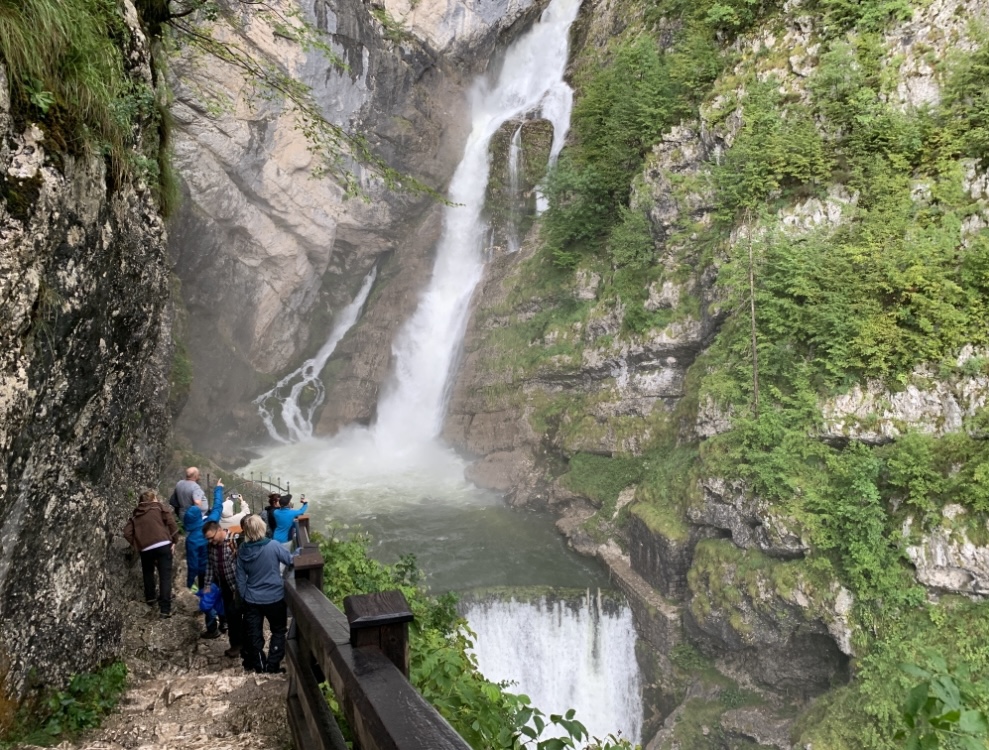
Overall, this hike will test your legs, stamina and give you a good workout. Unless this is your goal, there are plenty of other hikes in neighboring Italy or Austria that are more rewarding and less demanding. Or you can just head on over Slap Savica which is a nice waterfall about one hour from Bled.