Last Updated on June 27, 2025
The Blue Mountains National Park is just over an hour drive from Sydney Airport. It is a nice change of pace from the hustle and bustle of Sydney. If you want to be with nature, the Blue Mountains is one of the many destinations that is less than a tank full of gas away.
We spent a couple of nights in Leura which is one of the towns within the Blue Mountains. Unlike national parks in the US, the Blue Mountains National Park integrates nature with development. The development is mainly residential houses that you have to go through to access the park. It is a no-fee park.
Here we describe our experience during our short exploration of the park. We briefly talk about what the weather was like, the tracks that we did and did not do and some of the viewpoints.
Weather in June
We visited the Blue Mountains in June 2023 which was the start of the winter season in the southern hemisphere. The area is at a higher elevation than Sydney. A single layer of clothing was comfortable under the sun, another layer would be better if it was cloudy or under a shade and three or four layers would be needed at night when the temperature drops down to a three or four degrees Celsius above freezing.
We did not experience rain as it was the dry season. It did get windy making it a chilly day. Still, it was enjoyable to be outdoors.
Park In A Nutshell
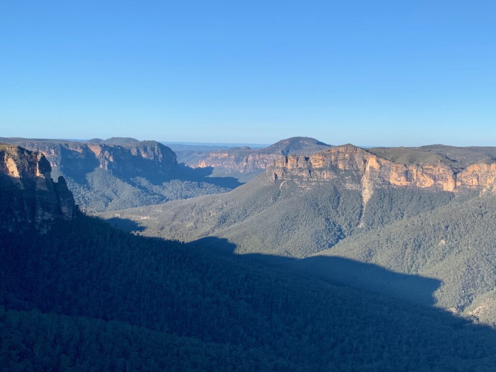
The park is large and one or two days would not be enough to visit the different viewpoints or hike its many tracks (trails). The Blue Mountains is mainly sandstone that has been eroded by creeks and rivers to form a wide canyon. Though not as wide as Grand Canyon National Park in Arizona, its canyon spans about a kilometer or two across, providing some impressive viewpoints.
Majority of the Blue Mountains is covered with lush vegetation. The only thing exposed are the vertical cliffs.
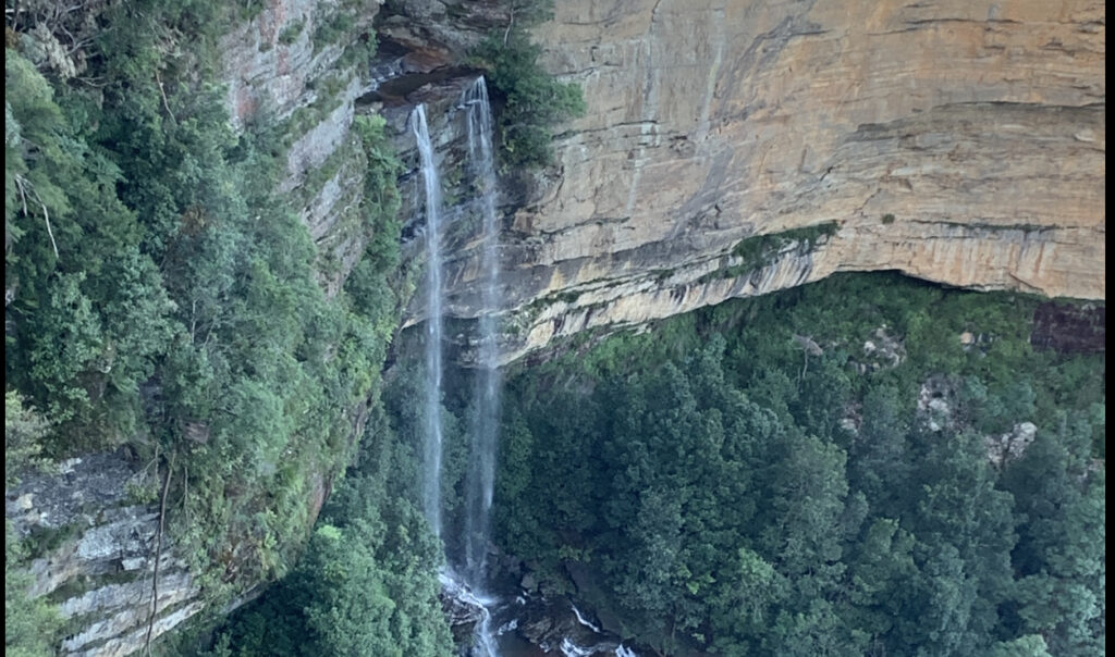
There are multiple creeks and rivers that form waterfalls that cascade down the canyon.
The Grand Canyon Hike
The Grand Canyon Hike is a 5.8 kilometer (give or take) circular loop track. Its trailhead is about a 30 minute drive from the town of Leura. The track’s trailhead information said it is a 3 to 4 hour hike. We completed it just under 5 hours at a leisurely pace with a 30 minute lunch break.
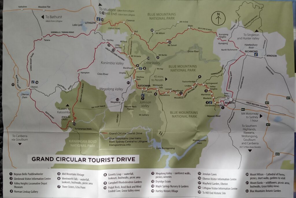
The track can be accessed from three parking lots. The first parking lot is Neates Glen Parking Area and only has space for about 10 vehicles. It is just a dirt area on the right side of Evans Lookout Road. The second parking lot is the Grand Canyon Car Park which is much bigger and paved. The third parking lot is Evans Lookout Parking Area and is also paved. It is at the end of Evans Lookout Road just a stone’s throw away from Evans Lookout.
The Grand Canyon track is best tackled in a counter-clockwise direction, according to some of the reviews in Alltrails. We think the counter clockwise direction was recommended because it is a less steeper ascent than the other way to get back on the canyon rim.
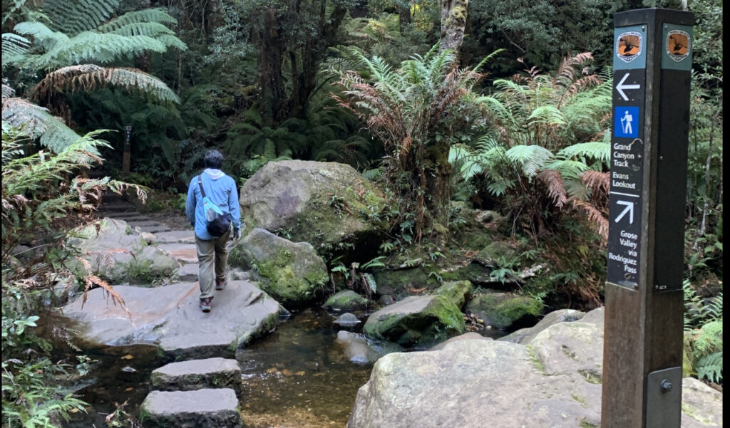
We parked at the Grand Canyon Car Park and followed the signs. The track parallels the road up to the Neates Glen Parking Area. It then turns towards the canyon and through a series of steps and switchbacks. Some portions of the track were wet though not muddy.
The descent ends at Greaves Creek which needs to be crossed. It then becomes somewhat level with a few short ascents and descents as the track follows the canyon. Most of the time the track is above the creek and occasionally dips down to cross it only to ascend again prior to the next crossing.
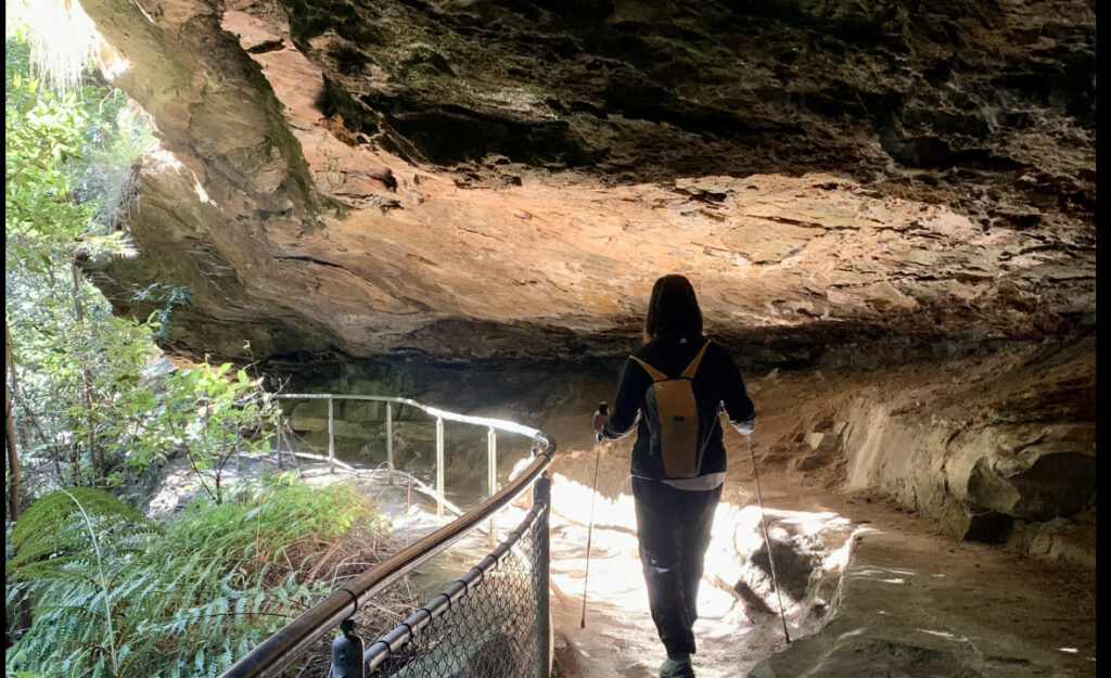
There are no panoramic views throughout the track. The draw of the Grand Canyon track is the many sandstone undercuts that the hiker passes underneath. The trail also goes through a short tunnel and behind a waterfall about 5/8ths of the way. Other unique features of the track are a few creek crossing areas that beckoned us to stop for a bit and soak in the surrounding.
Evans Lookout to Govetts Leap Viewpoint Track
We did not have time to do this track but I thought it would be worth mentioning. It is an out and back track that parallels the cliff edge. If you have two vehicles, one can be dropped off at one end to avoid the return hike. It is only a 15 minute drive to get from one end to the other.
We included this because we distinctly remember from reading the track information that it provided spectacular views. Maybe so as the track parallels the cliff edge. Unfortunately, we did not take a photo of the track description. Whether true or not depends on the eyes of the beholder.
Govetts Leap Viewpoint
This was the most impressive viewpoint of all the viewpoints we were able to visit. It provides a perspective of the canyon’s width. There are also viewing platforms to two waterfalls. Unfortunately, the viewing platforms require some effort to get to as it is located below the viewpoint. This means that an ascent would be required to get back to the viewpoint.
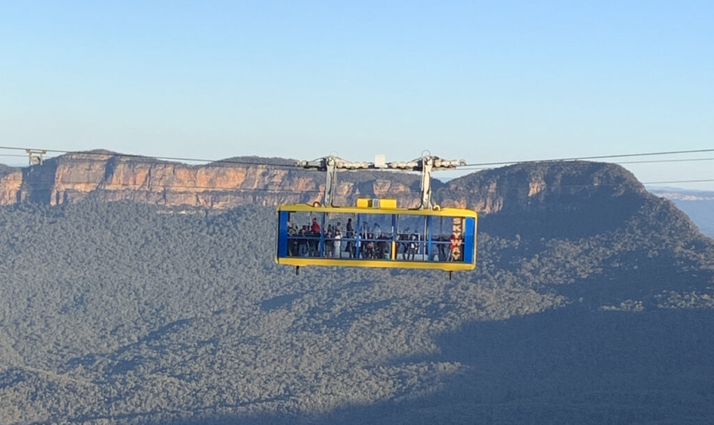
Katoomba Falls
Our next stop after Govetts Viewpoint was Katoomba Falls. We passed the Scenic World aerial tram along the way. We just parked at the local park parking lot, crossed the road to get to the viewpoints. There are several viewpoints of the canyon and you can also watch the aerial tram slowly pass by.
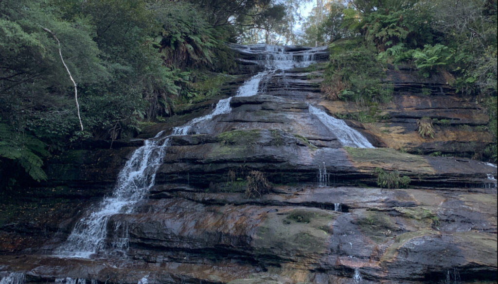
There is also a short walk that has minimal elevation change to Katoomba Cascades. You will be rewarded by the Katoomba River cascading over a slanted rock formation about 10 meters high.
Another draw of Katoomba Falls is that the walking paths have low wattage lighting from dusk to about 11 PM according to our host. She said that the area is lit up including the falls. Unfortunately, we did not stick around to find out as it became windy and chilly.
Three Sisters
If you Google Blue Mountains NSW, chances are that there would be a few images of the iconic Three Sisters. The Three Sisters are rock spires in close vicinity of each other. The best place to view these spires, in our opinion, is at the Three Sisters viewpoint as this is the closest viewpoint to the rock formations.
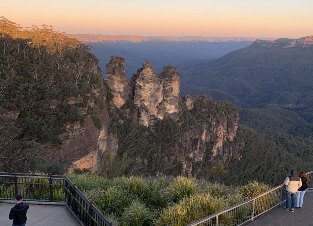
We went to the viewpoint close to 5PM on a Saturday and it was buzzing with people. The street parking was mostly taken. It is definitely worth the extra effort.
Getting To The Blue Mountains From Sydney
We rented a car from the Mascot suburb as it is walking distance from the domestic airport (T2 and T3). It was also walking distance from our hotel accommodation. There is a free airport shuttle that runs between T1 (international terminal) and T2 and T3.
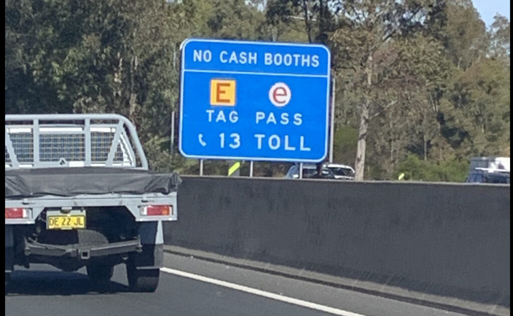
We took the M4 toll road to get to the Blue Mountains. Sydney’s toll roads are cashless so we were concerned how we were going to pay for the toll fee as our rental car did not have a physical transponder that would beep as soon as we entered the toll road. Fortunately, paying Sydney’s toll system is painless.
In a nutshell, a third party receives the rental car license information. Because the rental car company has our credit card information, the toll road third party accesses this information and billed our credit card directly. The toll charge appears a week or two later in our on-line credit card statement. It would be prudent to verify from your car rental company if they have the same arrangement regarding the toll road payment.
Besides driving on the left side of the road, Sydney’s roads are not built the same as the US where we can conveniently make left turns (right turns here) at intersections. Intersections with traffic lights that allow right turns are few and far in between. So if you miss your turn, you may have to drive a while before reaching another.
Summary
The Blue Mountains National Park is just over an hour drive from Sydney. It is a big park that integrates nature with residential development. It is a no-fee park.
We did not see any mountaintops jutting out of the horizon. Rather, the Blue Mountains have a lot of canyons that have been carved by rivers and creeks. The canyons are rather wide in some places, reaching a kilometer or more across. There are several viewpoints and tracks to make outdoor recreation enjoyable. We did the Grand Canyon Track that allowed us to get close to eroded sandstone, cross a few creeks and get behind a waterfall.
The Blue Mountains is a nice change in scenery if you get tired of roaming Sydney. Trees abound and the traffic is non-existent. Whatever your desire is, the Blue Mountains is a worthwhile side trip from Sydney.