Last Updated on June 27, 2025
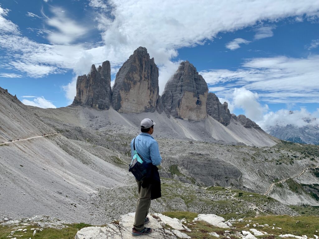
If you Google “Dolomites”, chances are an image of Tre Cime di Lavaredo would pop up. Tre Cime di Lavaredo or Tre Cime for short loosely translated means “three tops” or “three peaks”. It is one of the more popular hiking destinations in the Dolomites.
We visited and hiked around the Tre Cime area in late August 2023. We describe here our experience to help you plan your Tre Cime adventure. This blog talks about where Tre Cime is located, how to get to it, the hike description and what we missed out on by not having the information we know now.
Where is Tre Cime?
Tre Cime is located in Northern Italy. As the crow flies, it is roughly 170 kilometers north of metropolitan Venice and about 15 kilometers south of the Austrian border. Just enter “Tre Cime di Lavaredo” in Google Maps to pinpoint the location.
How to Get to Tre Cime
There are primarily two ways to get to Tre Cime. One is to drive yourself there and the second is to take a shuttle bus.
Driving
We stayed in the town of Dobbiaco (Toblach in German) which is to the north and west of Tre Cime. It took roughly 40 minutes to get to the parking area just below Rifugio Auronzo. This did not include the waiting time through the toll gate to get up to the parking lot.
The toll payment booth is about 2 kilometers down the road after turning from the Strada Provinciale (SP) 49 near Lago Misurina. There are two booths but only one was manned when we went on a Friday. We arrived at the toll booth around 8 AM and there was already a line of cars about 20 long ahead of us.
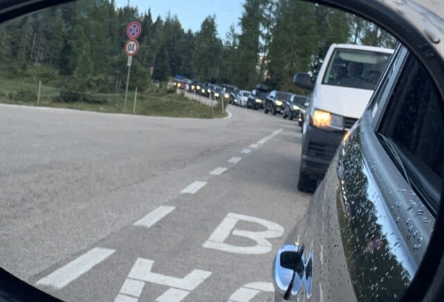
The Internet says that there are 700 parking spaces at the parking lot below Rifugio Auronzo. When we arrived, there were about 250 parking spaces left as indicated by a digital board on the side of the road beside the toll payment booths.
The toll fee was 30 Euros. You can pay by credit card or cash. Better have both in case the credit card reader has issues. We were given a ticket after paying the toll. Hang on to the ticket as that will automatically raise the exit gates on the way out.
On the way out, there are two exit gates. The gate on the right as viewed from the driver’s seat is for those that have paid the toll fee. The gate on the left is for those who have not paid or have lost their ticket (make sure you save the payment receipt to show proof in case you lose the ticket).
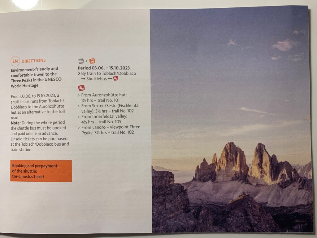
Shuttle Bus
There are shuttle buses from Cortina d’Ampezzo, Misurina and Dobbiaco. Bus 444 shuttles people from Dobbiaco. Tickets need to be purchased online and in advance.

The Hike
Trail 101 to Rifugio A. Locatelli
The most popular trail is 101 which starts from Rifugio Auronzo and takes hikers to Rifugio Lavadero and Rifugio A. Locatelli. Trail 101 is accessed by going to the right side of Rifugio Auronzo where the trail will be visible as it hugs the side of the mountain.
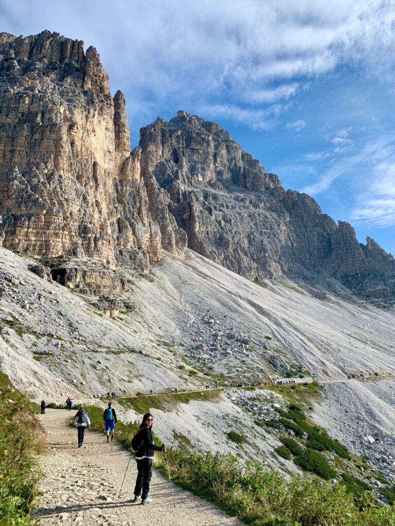
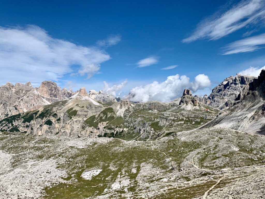
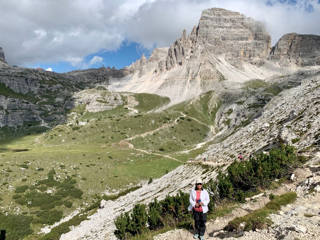
Trail 101 will take you around the back side of the Tre Cime. The three gigantic peaks are not recognizable from the back side. The trail is level up to Rifugio Lavaredo. Past this rifugio, the trail climbs up to the saddle about 15 to 20 minutes away. The trails leading to the saddle are visible from the rifugio. The climb to the saddle is not terribly high, maybe a couple of hundred feet or so.
An awe inspiring panoramic view of the mountain range becomes visible at the saddle. The Tre Cime is now recognizable from this location although the view is more from the side rather than being in front. Most hikers mill around this area to take in the beauty and take lots of pictures. Rifiguo A. Locatelli is also visible from the saddle.
There are primarily two trails that lead hikers from the saddle to Rifugio A Locatelli. We are not sure which one is the official Trail 101. We took the trail on the left where it descends before climbing up at the end to get to the rifugio. The advantage of taking the trail on the left is that it is closer to Tre Cime compared to the trail on the right. The Tre Cime looks bigger in the picture. The disadvantage of taking the trail on the left is that it involves more elevation gain compared to the trail on the right.
The trail to the right of the saddle stays high and even goes higher in some locations until it reaches Rifugio A. Locatelli. The advantage of this trail is that there is less elevation change compared to the trail on the left.
Rifugio A. Locatelli
RIfugio A. Locatelli gets pretty busy in the hours leading to and right after lunch time. We had their Carbonara and Spaghetti aglio e olio and they were both delicious and filling. The rifugio does not accept credit cards so be prepared to pay in cash.
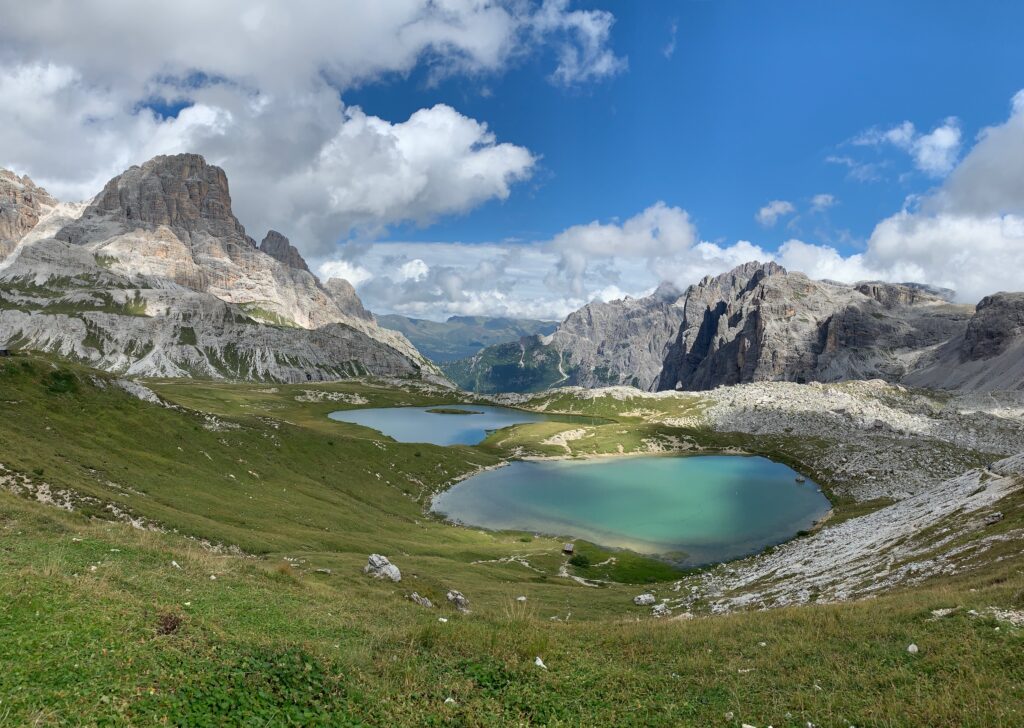
To the east (right) of the rifugio is a view of two small lakes and more mountains. There are patches of grassy sloping areas perfect to spread a ground cloth and lie down to take a nap.
There are also some areas below and in front of Riifugio A. Locatelli that are great for taking photos of Tre Cime because it is squarely in front.
Trail 105 Back to Rifugio Auronzo
Some people take the same Trail 101 back to Rifugio Auronzo because it is less demanding than Trail 105. Some people take Trail 105 first going in a clockwise direction to Rifugio A Locatelli. Some people prefer going in a clockwise direction because they face Tre Cime as they take Trail 101 back to Rifugio Auronzo.
Trail 105 goes down to the valley between the Tre Cime and the Rifugio A. Locatelli then it goes up again. Because the trail descends to the valley, you have more elevation gain in front of you to get back to the Rifugio Auronzo.
Trail 105 provides a view of Tre Cime from a different angle. It also passes by Langalm alpine hut. You can order food and drink at this hut. There are seats outside the hut where you can admire the Tre Cime as you savor your food and/or drink.
Cadini di Misurina
Cadini di Misurina is a short hike that starts from Rifugio Auronzo. This hike provides awe-inspiring views of a mountain group defined by jagged spires and pinnacles. We only knew about this hike a couple of days after we completed the Tre Cime hike. So it was a missed opportunity for us that we hope does not happen to you. Otherwise, you will have to pay the toll fee again or start the hike before the toll road payment booth which would be a longer and harder hike.
So if you have the stamina, you may want to combine the Cadini di Misurina hike with the Tre Cime hike. We would advise to do this short hike first before tackling the Tre Cime hike. The Tre Cime hike is longer and you may not have the energy later in the afternoon to do the Cadini di Misurina.
Summary
Tre Cime are the iconic three peaks in the Dolomites. It is a popular hiking destination. The start of the hike is from Rifugio Auronzo which is reachable by car or by shuttle bus. There is limited parking at Rifugio Auronzo so plan on arriving early. You must also pay the toll road fee to drive to the parking lot.
Most people hike to Rifugio A Locatelli from Rifugio Auronzo on Trail 101. The hike to Rifugio A Locatelli can be done in a clockwise, counter clockwise or out and back route. The easiest is out and back on Trail 101 as it has less elevation gain compared to tackling Trail 105 if you do a circular route.
The best view of the Tre Cime is just below Rifugio A. Locatelli as the three peaks are squarely in front of you. Plus you can have a tasty meal at the rifugio.
Regardless of how you want to experience Tre Cime, it will definitely put a smile on your face and make memories that would last a lifetime.