Last Updated on June 27, 2025
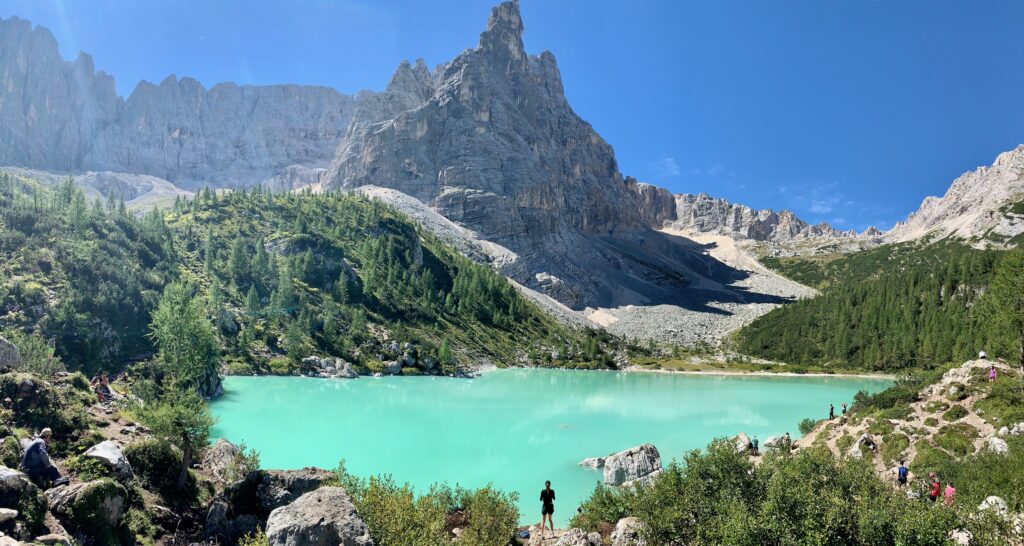
Lake Sorapis is an alpine lake tucked in the mountains that bear the same name. The lake can only be reached by foot with a significant elevation gain. According to AllTrails, the hike to the lake and back is about 7.6 miles long with a total elevation gain of 1,916 feet.
Lake Sorapis is a popular hike and is one of the many hikes that would show up if you Google “hikes in the Dolomites”. This happens for a good reason. The lake with its turquoise color is framed by a gigantic mountain. There is also Rifugio Al Sorapis nearby but it is tucked behind the trees and away from the lake.
We visited Lake Sorapis in early September 2023. Here we describe how to get to the trailhead, the hike, the crowd, where the best spot is to take photos and other helpful hints to help you plan your exploration.
Trailhead Location
The trailhead is located about a stone’s throw away east of Passo Tre Croci. Passo Tre Croci is between Cortina d’Ampezzo and Misurina on Strada Regionale 48 (SR48). You have passed the trailhead if you are coming from Misurina and reached Ristorante Baita Son Zuogo which is at Passo Tre Croci.
However, there is no parking area at the trailhead. The parking area is located just east of the restaurant. At the time of our visit, SR48 was closed between Cortina d’Ampezzo and about a kilometer and a half east from Ristorante Baita Son Zuogo (right before the bridge). We had to park on the side of the road and walk approximately one kilometer to the trailhead.
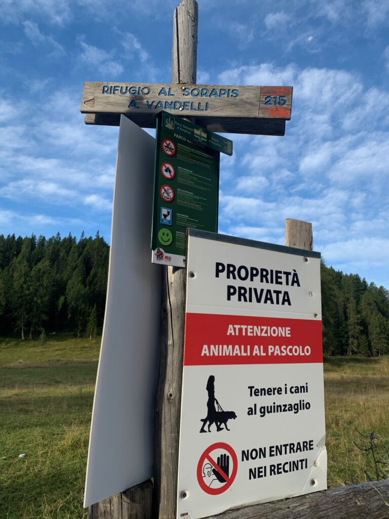
At the trailhead, there is a sign in Italian that says “No Entrare Nei Recinti”. which translates to “No Entering the Enclosures”. But there is a man gate there and a well worn trail behind it plus Trail 215 sign to Rifugio Al Sorapis. We just opened the man gate, closed it behind us and went in. Nobody yelled.
The Trail
It took us about 2.5 hours to reach Lake Sorapis from the trailhead which is consistent with the trail’s information sign. If you are a strong hiker, you would complete it faster just like the people that passed us. The trail basically wraps around the northeast side of the mountain.
We started our hike around 7:30 AM. The first hour of the hike was fairly level and through the forest. The trees shielded us from the sun during that time in the morning so the hike was mainly through shade. After an hour, the trail begins to climb and soon after becomes more exposed. You would be able to see the hotel in front of Lake Misurina, the backside of Tre Cime and RIfugio Auronzo if you look over your left shoulder. The Cadini mountains would also be visible.
You would be constantly ascending from here on out until you reach the lake. You will encounter short sections of the trail with cables to grab on to. The cables are there so you can pull yourself up, prevent you falling if you lose your footing on the slippery rocks or just to give a sense of security as you walk along a narrow trail section with steep dropoff.
Besides the cables, there are also metal stairs that you will have to tackle. Fortunately, the metal stairs do not have high steps and are not very long (less than 50 steps). But that’s not all the obstacles that you will face on your quest to see the beautiful lake. After completing the first stair, you will have to watch your footing as you will have to step over smooth rocks and exposed tree roots. Take your time in this area so you do not trip and fall.
After an hour or so of going through the tree root obstacle course, you will face the final climb that has some metal gratings on the trail. Then you come to a signed junction to the lake and to Rifugio Al Sorapis. The lake is only a minute or two from here.
Where to Take the Best Photos
The best place to take photos is at the outlet end of the lake. This is the area to the left or to the right of the trail leading to the lake. What makes this area good for taking photos is the gigantic mountain in the background. It just line’s up and on center with the lake. Just find a spot to your liking.
There is a trail that goes around the lake. But the trail stops when it hits the vertical face of the mountain to the left of the lake just before the outlet. Some people walk over to the grassy and flat area opposite the outlet end of the lake. Do not bother going there unless you want to sunbathe. The trail is narrow, you have to step over rocks and the view from that side is not worth taking a photo.
GO Early Morning or Late Afternoon
We started our hike early in the morning. The sun hit us on the exposed section of the trail but it was OK as it was still mid morning. At the lake, there were only a few people taking photos. So jockeying for position and taking a photo without being photobombed was not an issue. We took our photos without having to wait long for our turn at several spots.
At around noon, the area at the outlet end was much different compared to two hours ago. There were more people hanging around the area such that it was almost impossible to take that selfish shot. It did not get any better until we left around 2 PM.
On the way down the trail, there is a steady stream of people still coming up. You will be hard pressed to find a peeing window as there is not much break in the trail from the people going up and down.
The trail is now warm to hot in the exposed section. At 2 PM, the sun has not yet gotten behind the mountain. We only got shade once more when we hit the forested section of the trail.
If we were going to do this hike again, we would probably start out at 2:30 PM at the trailhead. We would reach the exposed section at 3:30 PM. We may still get hit by the sun but by 4 PM it should be behind the mountain so that the rest of the trail would be in the shade. We would reach the lake at around 5:00 PM and have about an hour to soak it in before leaving at 6 PM. It does not get dark until 8:30 PM anyway during the summer. The only disadvantage is that it will make for a late dinner unless we brought our dinner to the lake.
Summary
Lake Sorapis comes out as one of the top hikes in the Dolomiti if you do a Google search. It shows up for a good reason. The lake is an alpine lake tucked in the mountains that bear the same name. The lake is surrounded by mountains that provide memorable picture opportunities.
It is not easy to reach the lake. SR48 was closed during our visit so no bus was running this route. You pretty much have to drive yourself as close as possible to the trailhead.
The trail starts out level and through the forest for the first hour. At the start of the second hour, the trail constantly ascends and becomes more exposed and warmer as it is on the northeast side of the mountain. There are some cables and stairs to tackle but nothing that requires special equipment. There are also smooth rocks and exposed tree roots to watch out for to avoid slipping and tripping.
At the lake, just find a good spot at the outlet end of the lake. This is where the best shots can be taken. Do not bother going to the grassy flat area on the other side. The trail is narrow, over big rocks and the view is not worth the effort.
Hiking back in the early afternoon would be warm to hot as the trail would still be exposed. Late afternoon would be better once the sun has gotten behind the mountain.
Lake Sorapis is a popular destination. There was a steady stream of hikers going to the lake even in the early afternoon. It is best to tackle this hike early in the morning or late in the afternoon to beat the crowd or beat the sun and have that Instagram photo without being photo bombed.