
Highlights
Twenty plus kilometer hike to the lake at the base of of Mount Fitzroy. This hike took over 10 hours to complete including a couple of hours at the lake.
Time of Visit: December 2023
Duration of Visit: Day Hike from El Chalten
Description
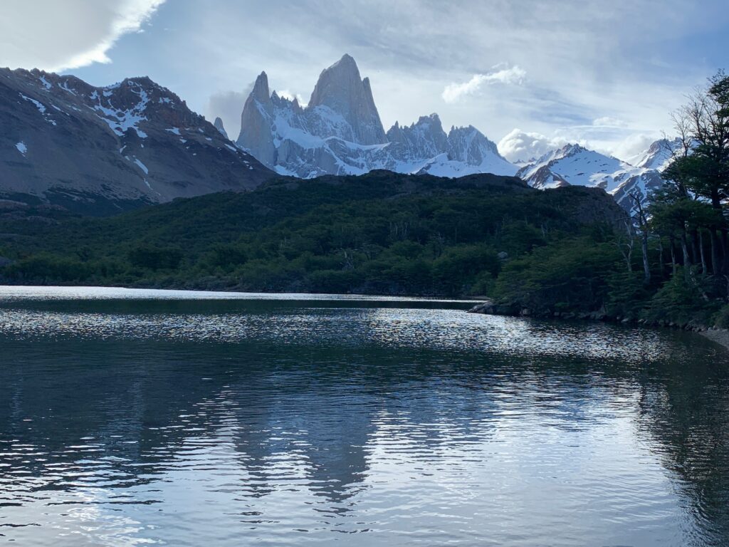
Laguna de los Tres is probably the most popular hike in El Chalten and Los Glaciares National Park. It is popular for a good reason. The scenery along the way and the destination are absolutely stunning. The destination is the pinnacle called Mt. Fitz Roy and its surrounding peaks as well as the stunning blue lake in front of it.
The hike is not easy as it is long and involves a substantial amount of elevation gain. A strong hiker would complete the hike in about eight hours, four hours in and four hours back. Factor in the time spent at the destination and you are easily looking at nine hours. It took us a total of 11.5 hours as we are not strong hikers and spent more than an hour admiring the scenery at the base of Mt. Fitz Roy.
Weather
We visited El Chalten in mid-December for two nights. It was at the tail end of spring in the southern hemisphere. Coming from the US which was winter, it did not feel any different in temperature because it was cool to cold in El Chalten. It was very windy also. Most visitors were wearing down jackets to keep warm and a raincoat or windbreaker to cut the wind down.
There was still snow on the mountain peaks and the lake at the base of Mt. Fitz Roy was still mostly covered in ice. It was mostly cloudy during our visit. We were mainly concerned that we would not see Mt. Fitz Roy as it was shrouded in clouds on the day we arrived. But we lucked out and it cleared during our hike. In short, the weather in El Chalten, except for the wind and temperature, was unpredictable.
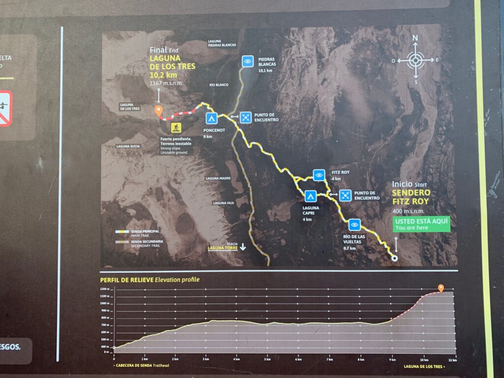
Two Ways to LagUNA de los Tres
There are two ways of doing the hike to Lago de los Tres. The most common way is the out and back way from the edge of town that starts and ends at Sendero Fitz Roy (also called Senda al Fitz Roy) trailhead. The other way is to take a shuttle bus that would drop hikers off Sendero Laguna de los Tres trailhead. By taking the shuttle bus, the journey forms a triangular route.
Our accommodation host suggested to us the shuttle bus. Her main point was that we would see more as the scenery would be different on the way to Laguna de los Tres compared to the return leg to El Chalten. We found that to be very true.
Our host forgot to mention that by taking the shuttle bus, we avoid the long ascent from the edge of town that one would have to tackle if they decided to do the out and back route. The shuttle bus route still includes some elevation gain but not as much as the out and back route in our opinion. You would have to tackle elevated steps in the out and back route as you ascend the trail on the way to the destination while the shuttle bus route has a gradually ascending trail.
Our Hike
We took the shuttle bus route. As mentioned earlier, this route is a triangular route. The first leg of the route is the bus ride from El Chalten to Sendero Laguna de los Tres trailhead.
The second leg is the hike from the Sendero Laguna de los Tres trailhead to the junction with the trail from El Chalten. It is approximately 10 kilometers with moderate elevation gain. The junction is a few minutes away from the Poncenot Campground.
The third leg is from the trail junction to Laguna de los Tres which is at the base of Mt. Fitz Roy. This is the most challenging part of the hike as it is about two kilometers of uphill climb. This leg passes through the Poincenot Campground.
The fourth leg is the return trip to El Chalten from the trail junction. It is about 8.5 kilometers back to El Chalten from the junction.
Leg 1 – Shuttle Bus Ride

We had the choice of taking the 8AM or 9AM shuttle bus. We opted for the earlier shuttle bus anticipating we would need an early start because we would take longer than eight hours to complete the hike. Our host called in to the shuttle bus company to reserve our seats.
The shuttle bus cost was 4,000 ARS per person (this was the day before Argentina decided to devalue its currency resulting in one USD going from 364 ARS to about 800 ARS). We paid our host directly and she gave us a voucher to show the shuttle bus driver before we could board the bus.
The shuttle bus was full and the ride took around 40 minutes on Ruta 23 (unpaved gravel road) until we were dropped off at the trailhead just before the Rio Blanco.
Leg 2 – Trailhead to Junction
We started our hike at 08:47 at Sendero Laguna de los Tres trailhead. We just followed the other hikers as they began the trek through the valley. The trail follows Rio Blanco though not adjacent to it. However, there are wooden stakes with red or yellow paint to mark the trail to avoid getting lost.
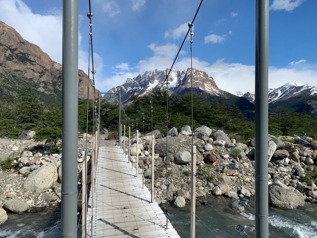
At 09:09, we encountered a fork in the trail. We took the left fork to follow the sign showing it is in the direction of Laguna de los Tres. At 09:39, we reached the suspension bridge to cross Rio Blanco. From here, the trail gradually ascended as it went through the forest which provided a nice relief from the wind. We had to shed layers too.
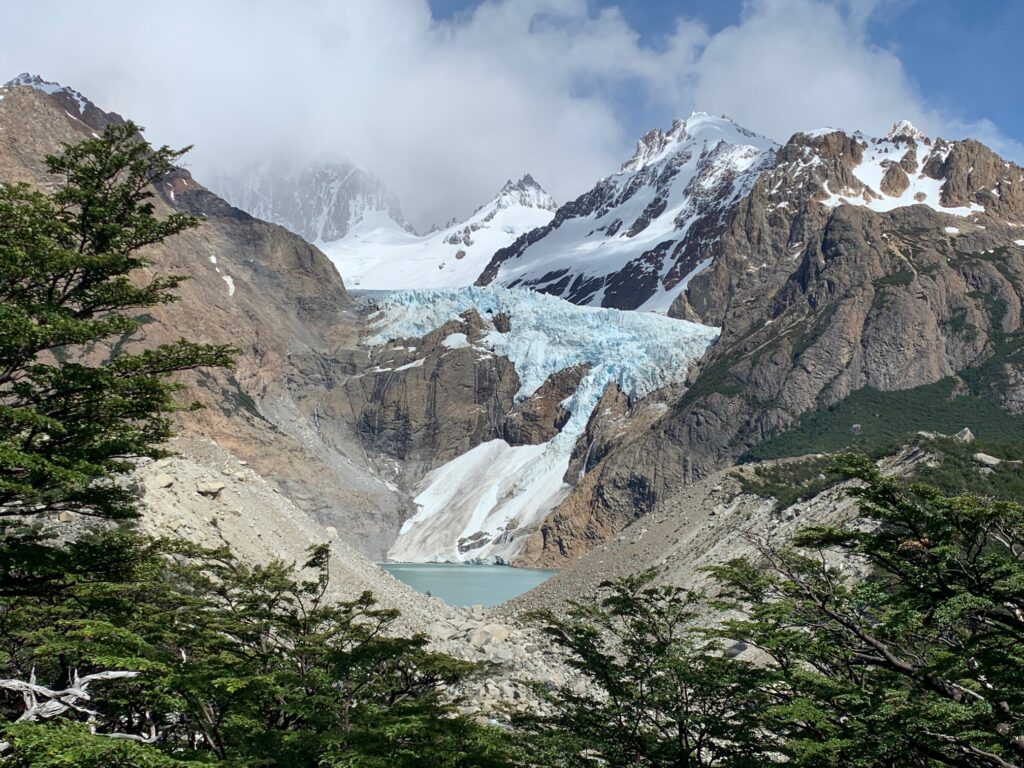
At 09:49, we reached the Parque Nacional Los Glaciares boundary. As we continue to ascend, there would be infrequent clearings in the forest that reveal the beautiful scenery of the valley and snow capped mountain range. At 10:41, we have our first glimpse of Glaciar Piedras Blancas which looks like it is hanging off the edge of the mountain ready to fall into the teal colored lake below.
We exited the forest and started walking through brushland at 11:27. From here, the hike was fairly level until we met up with the trail from El Chalten, i.e. the Junction.
Leg 3 – Junction to Lago de los Tres
It is less than five minutes between the Junction and Poncenot campground. The campground is in a forested area and there are warnings to be wary of falling branches especially during strong winds. Past the campground and out the forest, a wood bridge needs to be crossed en route to the beginning of the final ascent to Lago de los Tres. It was 11:57 when we reached this bridge.
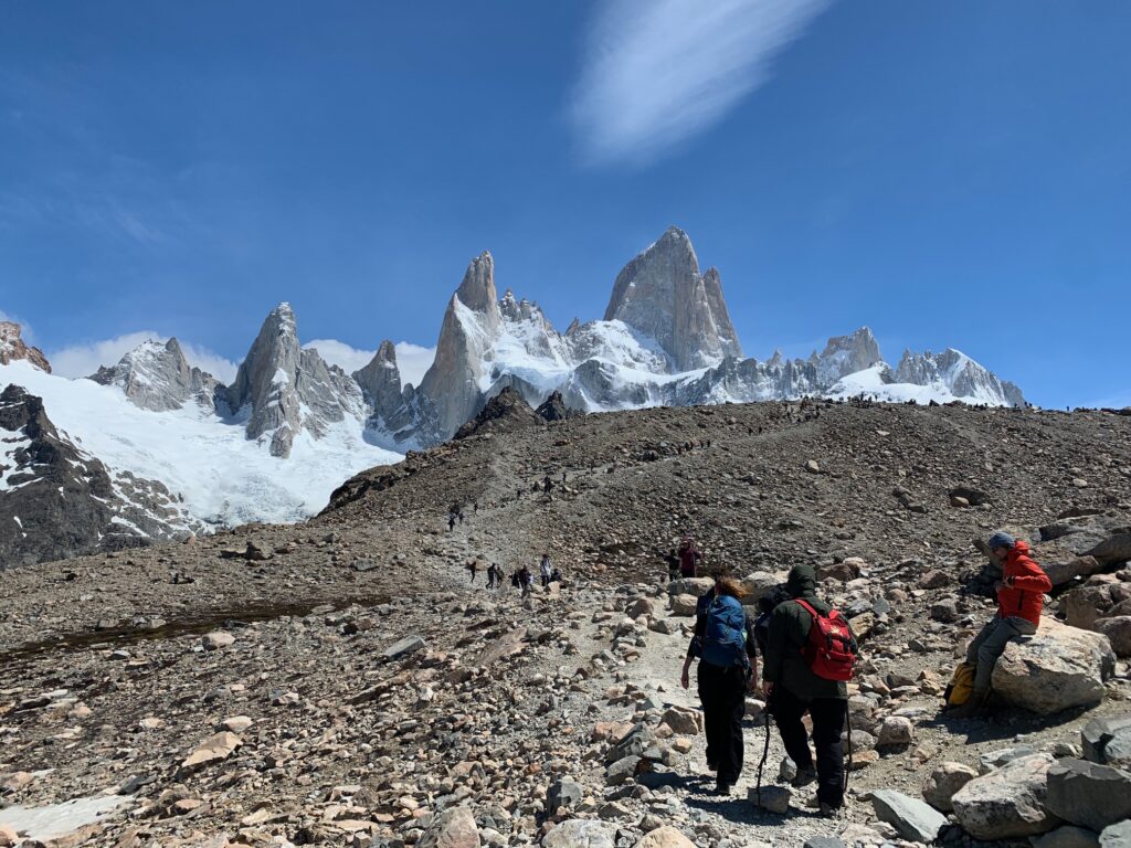
If you pause at the bridge and look at about 2 o’clock, you would see the other hikers climbing up the side of the mountain en route to the destination. Do not let this steep and final ascent scare you. It was not as hard as it looked.
At 13:50, the peak of Mt. Fitz Roy and other mountain peaks became visible. Then it was a short and steep scramble up to the viewpoint (about 10 minutes). The wind was especially strong throughout this stretch. Some people were crouching to avoid being blown over. It would be very helpful to have trekking poles for stability and eyewear for the blowing dust. Forget wearing a hat as it would be blown away. This means you will have to wear facial sunscreen.
We decided to go down at the edge of the lake thinking that it would not be as windy as the viewpoint. The wind was indeed less strong by the lake that we were able to take our time taking photos. Later the wind subsided and we found ourselves spending more time than we should have. It was 15:30 by the time we headed down back to the Junction where the wind continued to punish us with its gale force strength.
As a word of caution, take your time as you traverse Leg 3 in reverse. The rocks and dirt are sometimes loose. Make sure you have good footing before taking the next step. Just take your time to avoid slipping and tripping. It is not a race. Pause occasionally and look around and admire the beautiful views around you.
Leg 4 – Junction to El Chalten
We arrived at the Junction around 17:30. We thought that the downhill would be quicker than the uphill but it turned out to be not true as we took our time to make sure we had secure footings during the steep descent.

From the Junction, our backs were facing Mt. Fitz Roy. We were glad to turn around every once in a while or we would have missed taking some awesome photos. The trail remained fairly level and through a combination of brushland and forest until 18:30 where we hit a fork in the trail. Both trail branches would meet up though later in the hike. The left branch would pass through Mirador Fitz Roy while the right branch would pass by Lago Capri and a campground. We took the trail to the right and we were at Lago Capri at 18:45.
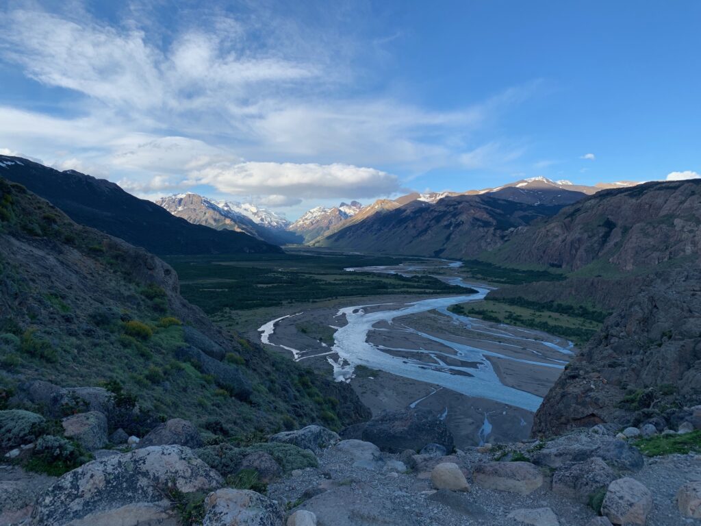
The campground was next to the lake. This was our last glimpse of Mt. Fitz Roy before the trail headed into the woods and began its long descent to El Chalten. It seemed this stretch of the hike took forever and felt like the longest three kilometers we ever tackled. The final reward of the hike was the view of the valley below leading to Mirador Rio de las Vueltas. We finally reached the Senda al Fitz Roy trailhead in El Chalten at 20:08.
How to Get to El Chalten
There are mainly three ways to get to El Chalten, by bus, by private transfers or by rental car (we have seen some people hitchhiking). We went via rental car as it was more economical for a party of four to travel to El Chalten and Perito Moreno Glacier than going by bus or private transfer.
We flew into the town of El Calafate which is the nearest town that has an airport. Our flight came in at almost nine in the evening at El Calafate so we had to stay overnight as the rental car office in town where we made our reservation closed at 8PM (there are rental car offices at the airport but we found a better deal with a company that has an office in town).
It is about 240 kilometers from El Calafate to El Chalten. It took us over three hours to make the drive due to strong winds, stopping too often to take photos and just driving cautiously in a treeless land with freely roaming animals around.
Summary
The Laguna de los Tres hike is one of the more popular hikes in El Chalten, Argentina. It is a long and strenuous hike if you are not a seasoned hiker. But the destination and the scenery along the way makes it worth it.
Taking the shuttle bus to Sendero Laguna de los Tres trailhead is probably the easier and more scenic way to get to Laguna de los Tres. The overall elevation gain is also less in our opinion compared to the out and back route from El Chalten. Still, it is not an easy task with roughly 22 kilometers and around 1,000 meters of total elevation gain, As one wise hiker once said to me, “You will forget the pain that you feel now after a week or so, but the beauty of this place will stay with you forever!”